You are here: Home > Network List > AU - Australian Seismological Centre Stations List
> Station TOO Toolangi, Victoria > Earthquake Result Viewer
TOO Toolangi, Victoria - Earthquake Result Viewer
| Earthquake location: |
Banda Sea |
| Earthquake latitude/longitude: |
-6.4/126.8 |
| Earthquake time(UTC): |
2011/08/30 (242) 06:57:41 GMT |
| Earthquake Depth: |
470 km |
| Earthquake Magnitude: |
6.0 MB, 6.9 MW, 6.9 MW |
| Earthquake Catalog/Contributor: |
WHDF/NEIC |
|
| Network: |
AU Australian Seismological Centre |
| Station: |
TOO Toolangi, Victoria |
| Lat/Lon: |
37.57 S/145.49 E |
| Elevation: |
604 m |
|
| Distance: |
35.4 deg |
| Az: |
153.883 deg |
| Baz: |
326.589 deg |
| Ray Param: |
0.07506742 |
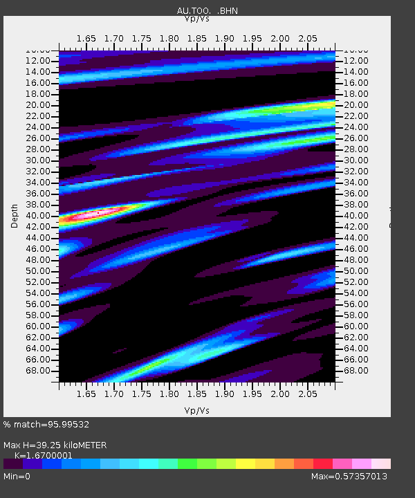
| Estimated Moho Depth: |
39.25 km |
| Estimated Crust Vp/Vs: |
1.67 |
| Assumed Crust Vp: |
6.577 km/s |
| Estimated Crust Vs: |
3.938 km/s |
| Estimated Crust Poisson's Ratio: |
0.22 |
|
| Radial Match: |
95.99532 % |
| Radial Bump: |
305 |
| Transverse Match: |
83.060455 % |
| Transverse Bump: |
400 |
| SOD ConfigId: |
414626 |
| Insert Time: |
2012-01-18 05:59:52.208 +0000 |
| GWidth: |
2.5 |
| Max Bumps: |
400 |
| Tol: |
0.001 |
|

Signal To Noise
| Channel | StoN | STA | LTA |
| AU:TOO: :BHZ:20110830T07:03:26.544998Z | 20.896135 | 7.780274E-6 | 3.7233076E-7 |
| AU:TOO: :BHN:20110830T07:03:26.544998Z | 17.20748 | 3.9897322E-6 | 2.3186034E-7 |
| AU:TOO: :BHE:20110830T07:03:26.544998Z | 7.2726965 | 2.2054005E-6 | 3.0324384E-7 |
| Arrivals |
| Ps | 4.3 SECOND |
| PpPs | 15 SECOND |
| PsPs/PpSs | 19 SECOND |


