You are here: Home > Network List > G - GEOSCOPE Stations List
> Station DZM Dzumac, New Caledonia > Earthquake Result Viewer
DZM Dzumac, New Caledonia - Earthquake Result Viewer
| Earthquake location: |
Banda Sea |
| Earthquake latitude/longitude: |
-6.4/126.8 |
| Earthquake time(UTC): |
2011/08/30 (242) 06:57:41 GMT |
| Earthquake Depth: |
470 km |
| Earthquake Magnitude: |
6.0 MB, 6.9 MW, 6.9 MW |
| Earthquake Catalog/Contributor: |
WHDF/NEIC |
|
| Network: |
G GEOSCOPE |
| Station: |
DZM Dzumac, New Caledonia |
| Lat/Lon: |
22.07 S/166.44 E |
| Elevation: |
878 m |
|
| Distance: |
41.4 deg |
| Az: |
116.298 deg |
| Baz: |
286.134 deg |
| Ray Param: |
0.0716309 |
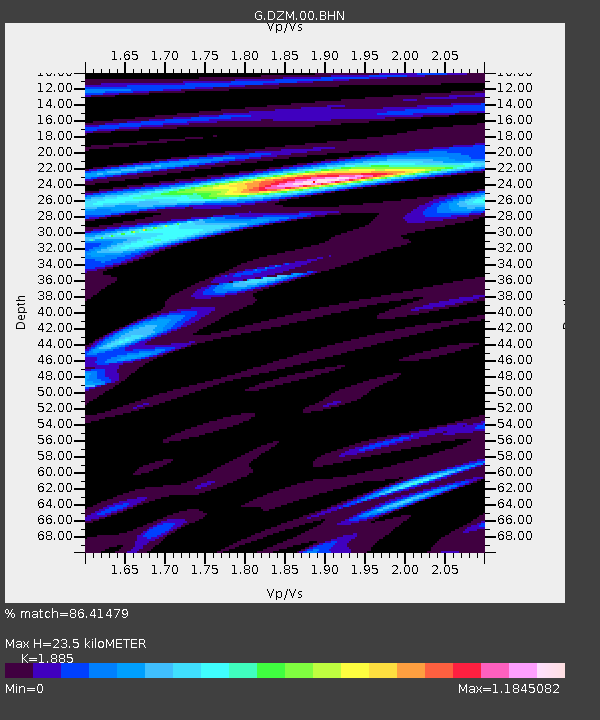
| Estimated Moho Depth: |
23.5 km |
| Estimated Crust Vp/Vs: |
1.88 |
| Assumed Crust Vp: |
5.14 km/s |
| Estimated Crust Vs: |
2.727 km/s |
| Estimated Crust Poisson's Ratio: |
0.30 |
|
| Radial Match: |
86.41479 % |
| Radial Bump: |
400 |
| Transverse Match: |
69.71869 % |
| Transverse Bump: |
400 |
| SOD ConfigId: |
414626 |
| Insert Time: |
2012-01-18 06:04:14.611 +0000 |
| GWidth: |
2.5 |
| Max Bumps: |
400 |
| Tol: |
0.001 |
|
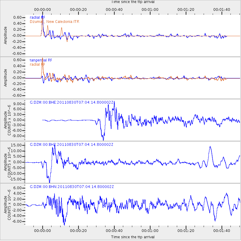
Signal To Noise
| Channel | StoN | STA | LTA |
| G:DZM:00:BHZ:20110830T07:04:14.800002Z | 34.11949 | 8.711977E-6 | 2.5533726E-7 |
| G:DZM:00:BHN:20110830T07:04:14.800002Z | 5.668729 | 1.5372779E-6 | 2.7118566E-7 |
| G:DZM:00:BHE:20110830T07:04:14.800002Z | 28.473274 | 5.3957306E-6 | 1.8950159E-7 |
| Arrivals |
| Ps | 4.2 SECOND |
| PpPs | 13 SECOND |
| PsPs/PpSs | 17 SECOND |


