You are here: Home > Network List > AZ - ANZA Regional Network Stations List
> Station LVA2 AZ.LVA2 > Earthquake Result Viewer
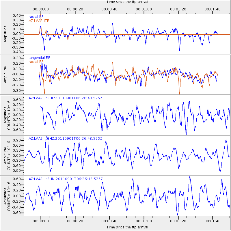
LVA2 AZ.LVA2 - Earthquake Result Viewer
*The percent match for this event was below the threshold and hence no stack was calculated.
| Earthquake location: |
Santa Cruz Islands |
| Earthquake latitude/longitude: |
-12.4/166.7 |
| Earthquake time(UTC): |
2011/09/01 (244) 06:14:38 GMT |
| Earthquake Depth: |
39 km |
| Earthquake Magnitude: |
5.7 MB, 5.6 MS, 6.1 MW, 6.0 MW |
| Earthquake Catalog/Contributor: |
WHDF/NEIC |
|
| Network: |
AZ ANZA Regional Network |
| Station: |
LVA2 AZ.LVA2 |
| Lat/Lon: |
33.35 N/116.56 W |
| Elevation: |
1435 m |
|
| Distance: |
85.9 deg |
| Az: |
54.772 deg |
| Baz: |
252.483 deg |
| Ray Param: |
$rayparam |
*The percent match for this event was below the threshold and hence was not used in the summary stack. |
|
| Radial Match: |
72.52627 % |
| Radial Bump: |
400 |
| Transverse Match: |
61.462402 % |
| Transverse Bump: |
400 |
| SOD ConfigId: |
414626 |
| Insert Time: |
2012-01-18 06:24:53.985 +0000 |
| GWidth: |
2.5 |
| Max Bumps: |
400 |
| Tol: |
0.001 |
|
Signal To Noise
| Channel | StoN | STA | LTA |
| AZ:LVA2: :BHZ:20110901T06:26:43.525Z | 2.1431396 | 5.900745E-7 | 2.7533181E-7 |
| AZ:LVA2: :BHN:20110901T06:26:43.525Z | 1.044543 | 1.6951563E-7 | 1.6228688E-7 |
| AZ:LVA2: :BHE:20110901T06:26:43.525Z | 0.6987601 | 1.8939312E-7 | 2.710417E-7 |
| Arrivals |
| Ps | |
| PpPs | |
| PsPs/PpSs | |


