You are here: Home > Network List > AZ - ANZA Regional Network Stations List
> Station SMER AZ.SMER > Earthquake Result Viewer
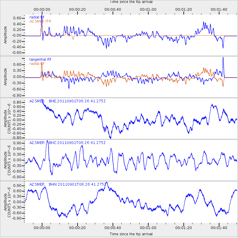
SMER AZ.SMER - Earthquake Result Viewer
*The percent match for this event was below the threshold and hence no stack was calculated.
| Earthquake location: |
Santa Cruz Islands |
| Earthquake latitude/longitude: |
-12.4/166.7 |
| Earthquake time(UTC): |
2011/09/01 (244) 06:14:38 GMT |
| Earthquake Depth: |
39 km |
| Earthquake Magnitude: |
5.7 MB, 5.6 MS, 6.1 MW, 6.0 MW |
| Earthquake Catalog/Contributor: |
WHDF/NEIC |
|
| Network: |
AZ ANZA Regional Network |
| Station: |
SMER AZ.SMER |
| Lat/Lon: |
33.46 N/117.17 W |
| Elevation: |
355 m |
|
| Distance: |
85.5 deg |
| Az: |
54.516 deg |
| Baz: |
252.13 deg |
| Ray Param: |
$rayparam |
*The percent match for this event was below the threshold and hence was not used in the summary stack. |
|
| Radial Match: |
56.08327 % |
| Radial Bump: |
390 |
| Transverse Match: |
53.88389 % |
| Transverse Bump: |
400 |
| SOD ConfigId: |
414626 |
| Insert Time: |
2012-01-18 06:24:56.185 +0000 |
| GWidth: |
2.5 |
| Max Bumps: |
400 |
| Tol: |
0.001 |
|
Signal To Noise
| Channel | StoN | STA | LTA |
| AZ:SMER: :BHZ:20110901T06:26:41.275Z | 2.1811178 | 5.01502E-7 | 2.2992889E-7 |
| AZ:SMER: :BHN:20110901T06:26:41.275Z | 1.5595661 | 6.286368E-7 | 4.030844E-7 |
| AZ:SMER: :BHE:20110901T06:26:41.275Z | 0.9666638 | 2.31953E-7 | 2.399521E-7 |
| Arrivals |
| Ps | |
| PpPs | |
| PsPs/PpSs | |


