You are here: Home > Network List > CI - Caltech Regional Seismic Network Stations List
> Station TIN Tinemaha, Big Pine, CA, USA > Earthquake Result Viewer
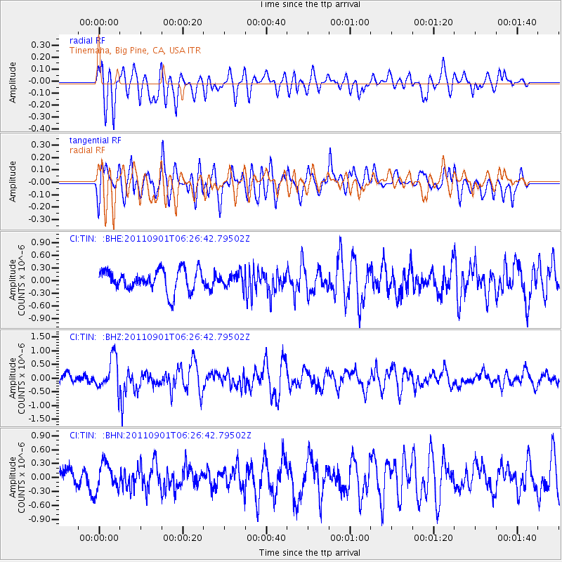
TIN Tinemaha, Big Pine, CA, USA - Earthquake Result Viewer
*The percent match for this event was below the threshold and hence no stack was calculated.
| Earthquake location: |
Santa Cruz Islands |
| Earthquake latitude/longitude: |
-12.4/166.7 |
| Earthquake time(UTC): |
2011/09/01 (244) 06:14:38 GMT |
| Earthquake Depth: |
39 km |
| Earthquake Magnitude: |
5.7 MB, 5.6 MS, 6.1 MW, 6.0 MW |
| Earthquake Catalog/Contributor: |
WHDF/NEIC |
|
| Network: |
CI Caltech Regional Seismic Network |
| Station: |
TIN Tinemaha, Big Pine, CA, USA |
| Lat/Lon: |
37.05 N/118.23 W |
| Elevation: |
1197 m |
|
| Distance: |
85.8 deg |
| Az: |
50.826 deg |
| Baz: |
251.241 deg |
| Ray Param: |
$rayparam |
*The percent match for this event was below the threshold and hence was not used in the summary stack. |
|
| Radial Match: |
56.015186 % |
| Radial Bump: |
400 |
| Transverse Match: |
72.713005 % |
| Transverse Bump: |
400 |
| SOD ConfigId: |
414626 |
| Insert Time: |
2012-01-18 06:26:16.935 +0000 |
| GWidth: |
2.5 |
| Max Bumps: |
400 |
| Tol: |
0.001 |
|
Signal To Noise
| Channel | StoN | STA | LTA |
| CI:TIN: :BHZ:20110901T06:26:42.79502Z | 3.7067995 | 6.1813967E-7 | 1.6675831E-7 |
| CI:TIN: :BHN:20110901T06:26:42.79502Z | 1.2888471 | 2.8203715E-7 | 2.1882903E-7 |
| CI:TIN: :BHE:20110901T06:26:42.79502Z | 0.6416322 | 1.6203865E-7 | 2.5254133E-7 |
| Arrivals |
| Ps | |
| PpPs | |
| PsPs/PpSs | |


