You are here: Home > Network List > CI - Caltech Regional Seismic Network Stations List
> Station SMM Simmler, CA, USA > Earthquake Result Viewer
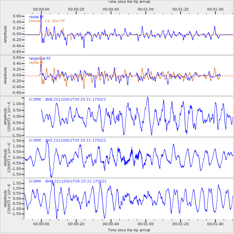
SMM Simmler, CA, USA - Earthquake Result Viewer
*The percent match for this event was below the threshold and hence no stack was calculated.
| Earthquake location: |
Santa Cruz Islands |
| Earthquake latitude/longitude: |
-12.4/166.7 |
| Earthquake time(UTC): |
2011/09/01 (244) 06:14:38 GMT |
| Earthquake Depth: |
39 km |
| Earthquake Magnitude: |
5.7 MB, 5.6 MS, 6.1 MW, 6.0 MW |
| Earthquake Catalog/Contributor: |
WHDF/NEIC |
|
| Network: |
CI Caltech Regional Seismic Network |
| Station: |
SMM Simmler, CA, USA |
| Lat/Lon: |
35.31 N/120.00 W |
| Elevation: |
599 m |
|
| Distance: |
83.9 deg |
| Az: |
52.0 deg |
| Baz: |
250.308 deg |
| Ray Param: |
$rayparam |
*The percent match for this event was below the threshold and hence was not used in the summary stack. |
|
| Radial Match: |
66.78482 % |
| Radial Bump: |
400 |
| Transverse Match: |
50.75421 % |
| Transverse Bump: |
310 |
| SOD ConfigId: |
414626 |
| Insert Time: |
2012-01-18 06:27:46.894 +0000 |
| GWidth: |
2.5 |
| Max Bumps: |
400 |
| Tol: |
0.001 |
|
Signal To Noise
| Channel | StoN | STA | LTA |
| CI:SMM: :BHZ:20110901T06:26:33.17002Z | 2.1284108 | 7.075066E-7 | 3.3241074E-7 |
| CI:SMM: :BHN:20110901T06:26:33.17002Z | 1.2527953 | 7.259314E-7 | 5.794493E-7 |
| CI:SMM: :BHE:20110901T06:26:33.17002Z | 1.1031865 | 4.6498906E-7 | 4.2149634E-7 |
| Arrivals |
| Ps | |
| PpPs | |
| PsPs/PpSs | |


