You are here: Home > Network List > TA - USArray Transportable Network (new EarthScope stations) Stations List
> Station O03D Paynes Creek, CA, USA > Earthquake Result Viewer
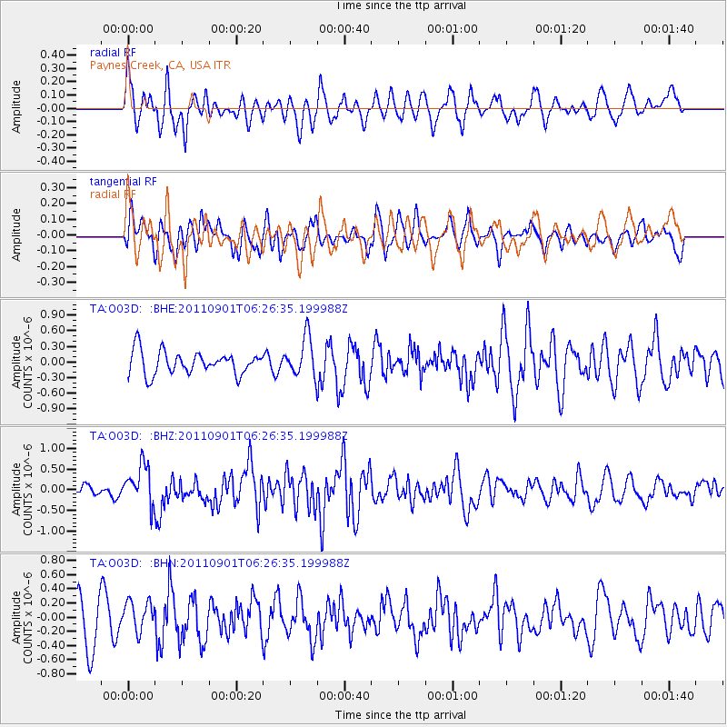
O03D Paynes Creek, CA, USA - Earthquake Result Viewer
*The percent match for this event was below the threshold and hence no stack was calculated.
| Earthquake location: |
Santa Cruz Islands |
| Earthquake latitude/longitude: |
-12.4/166.7 |
| Earthquake time(UTC): |
2011/09/01 (244) 06:14:38 GMT |
| Earthquake Depth: |
39 km |
| Earthquake Magnitude: |
5.7 MB, 5.6 MS, 6.1 MW, 6.0 MW |
| Earthquake Catalog/Contributor: |
WHDF/NEIC |
|
| Network: |
TA USArray Transportable Network (new EarthScope stations) |
| Station: |
O03D Paynes Creek, CA, USA |
| Lat/Lon: |
40.29 N/121.80 W |
| Elevation: |
968 m |
|
| Distance: |
84.3 deg |
| Az: |
46.815 deg |
| Baz: |
248.669 deg |
| Ray Param: |
$rayparam |
*The percent match for this event was below the threshold and hence was not used in the summary stack. |
|
| Radial Match: |
52.009476 % |
| Radial Bump: |
400 |
| Transverse Match: |
53.96317 % |
| Transverse Bump: |
400 |
| SOD ConfigId: |
414626 |
| Insert Time: |
2012-01-18 06:34:06.765 +0000 |
| GWidth: |
2.5 |
| Max Bumps: |
400 |
| Tol: |
0.001 |
|
Signal To Noise
| Channel | StoN | STA | LTA |
| TA:O03D: :BHZ:20110901T06:26:35.199988Z | 4.2096953 | 4.8407037E-7 | 1.1498941E-7 |
| TA:O03D: :BHN:20110901T06:26:35.199988Z | 0.68053365 | 2.2262458E-7 | 3.2713237E-7 |
| TA:O03D: :BHE:20110901T06:26:35.199988Z | 1.7505643 | 3.8268504E-7 | 2.1860666E-7 |
| Arrivals |
| Ps | |
| PpPs | |
| PsPs/PpSs | |


