You are here: Home > Network List > G - GEOSCOPE Stations List
> Station DRV Dumont d'Urville, Terre Adelie (Antartica) > Earthquake Result Viewer
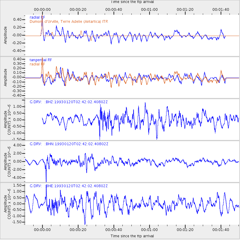
DRV Dumont d'Urville, Terre Adelie (Antartica) - Earthquake Result Viewer
*The percent match for this event was below the threshold and hence no stack was calculated.
| Earthquake location: |
Northern Sumatra, Indonesia |
| Earthquake latitude/longitude: |
3.1/97.7 |
| Earthquake time(UTC): |
1993/01/20 (020) 02:30:55 GMT |
| Earthquake Depth: |
71 km |
| Earthquake Magnitude: |
6.2 MB |
| Earthquake Catalog/Contributor: |
WHDF/NEIC |
|
| Network: |
G GEOSCOPE |
| Station: |
DRV Dumont d'Urville, Terre Adelie (Antartica) |
| Lat/Lon: |
66.67 S/140.01 E |
| Elevation: |
40 m |
|
| Distance: |
75.8 deg |
| Az: |
163.93 deg |
| Baz: |
316.059 deg |
| Ray Param: |
$rayparam |
*The percent match for this event was below the threshold and hence was not used in the summary stack. |
|
| Radial Match: |
61.59824 % |
| Radial Bump: |
400 |
| Transverse Match: |
69.04356 % |
| Transverse Bump: |
400 |
| SOD ConfigId: |
4480 |
| Insert Time: |
2010-02-26 22:14:48.994 +0000 |
| GWidth: |
2.5 |
| Max Bumps: |
400 |
| Tol: |
0.001 |
|
Signal To Noise
| Channel | StoN | STA | LTA |
| G:DRV: :BHN:19930120T02:42:02.40802Z | 5.171664 | 1.3460832E-6 | 2.6028047E-7 |
| G:DRV: :BHE:19930120T02:42:02.40802Z | 1.2249249 | 4.4459722E-7 | 3.6295873E-7 |
| G:DRV: :BHZ:19930120T02:42:02.40802Z | 1.6579252 | 4.748746E-7 | 2.8642702E-7 |
| Arrivals |
| Ps | |
| PpPs | |
| PsPs/PpSs | |


