You are here: Home > Network List > CI - Caltech Regional Seismic Network Stations List
> Station SWS Sam W. Stewart, Westmorland, CA, USA > Earthquake Result Viewer
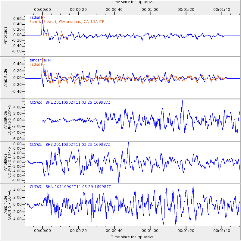
SWS Sam W. Stewart, Westmorland, CA, USA - Earthquake Result Viewer

| Earthquake location: |
Fox Islands, Aleutian Islands |
| Earthquake latitude/longitude: |
52.2/-171.7 |
| Earthquake time(UTC): |
2011/09/02 (245) 10:55:53 GMT |
| Earthquake Depth: |
32 km |
| Earthquake Magnitude: |
6.5 MB, 6.9 MS, 6.8 MW, 6.8 MW |
| Earthquake Catalog/Contributor: |
WHDF/NEIC |
|
| Network: |
CI Caltech Regional Seismic Network |
| Station: |
SWS Sam W. Stewart, Westmorland, CA, USA |
| Lat/Lon: |
32.94 N/115.80 W |
| Elevation: |
140 m |
|
| Distance: |
44.2 deg |
| Az: |
93.122 deg |
| Baz: |
313.003 deg |
| Ray Param: |
0.07198814 |
| Estimated Moho Depth: |
14.5 km |
| Estimated Crust Vp/Vs: |
2.10 |
| Assumed Crust Vp: |
6.155 km/s |
| Estimated Crust Vs: |
2.934 km/s |
| Estimated Crust Poisson's Ratio: |
0.35 |
|
| Radial Match: |
89.77635 % |
| Radial Bump: |
400 |
| Transverse Match: |
84.59082 % |
| Transverse Bump: |
400 |
| SOD ConfigId: |
414626 |
| Insert Time: |
2012-01-18 06:48:32.129 +0000 |
| GWidth: |
2.5 |
| Max Bumps: |
400 |
| Tol: |
0.001 |
|
Signal To Noise
| Channel | StoN | STA | LTA |
| CI:SWS: :BHZ:20110902T11:03:29.169987Z | 8.684179 | 3.1548934E-6 | 3.632921E-7 |
| CI:SWS: :BHN:20110902T11:03:29.169987Z | 3.0908465 | 1.4705348E-6 | 4.757709E-7 |
| CI:SWS: :BHE:20110902T11:03:29.169987Z | 5.05422 | 1.7942618E-6 | 3.550027E-7 |
| Arrivals |
| Ps | 2.7 SECOND |
| PpPs | 6.9 SECOND |
| PsPs/PpSs | 9.7 SECOND |


