You are here: Home > Network List > CI - Caltech Regional Seismic Network Stations List
> Station CIA CIA, Avalon Catalina Island, CA, USA > Earthquake Result Viewer
CIA CIA, Avalon Catalina Island, CA, USA - Earthquake Result Viewer

| Earthquake location: |
Fox Islands, Aleutian Islands |
| Earthquake latitude/longitude: |
52.2/-171.7 |
| Earthquake time(UTC): |
2011/09/02 (245) 10:55:53 GMT |
| Earthquake Depth: |
32 km |
| Earthquake Magnitude: |
6.5 MB, 6.9 MS, 6.8 MW, 6.8 MW |
| Earthquake Catalog/Contributor: |
WHDF/NEIC |
|
| Network: |
CI Caltech Regional Seismic Network |
| Station: |
CIA CIA, Avalon Catalina Island, CA, USA |
| Lat/Lon: |
33.40 N/118.41 W |
| Elevation: |
467 m |
|
| Distance: |
42.3 deg |
| Az: |
94.812 deg |
| Baz: |
312.808 deg |
| Ray Param: |
0.07319518 |
| Estimated Moho Depth: |
60.75 km |
| Estimated Crust Vp/Vs: |
1.82 |
| Assumed Crust Vp: |
6.048 km/s |
| Estimated Crust Vs: |
3.328 km/s |
| Estimated Crust Poisson's Ratio: |
0.28 |
|
| Radial Match: |
91.60832 % |
| Radial Bump: |
400 |
| Transverse Match: |
82.263245 % |
| Transverse Bump: |
400 |
| SOD ConfigId: |
414626 |
| Insert Time: |
2012-01-18 06:48:45.633 +0000 |
| GWidth: |
2.5 |
| Max Bumps: |
400 |
| Tol: |
0.001 |
|
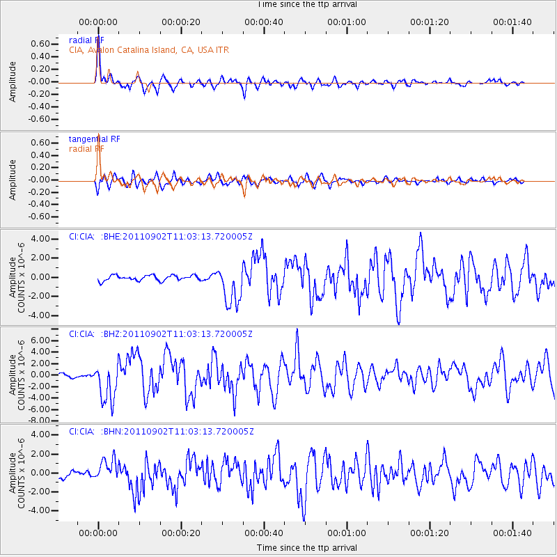
Signal To Noise
| Channel | StoN | STA | LTA |
| CI:CIA: :BHZ:20110902T11:03:13.720005Z | 7.4907928 | 3.4995576E-6 | 4.671812E-7 |
| CI:CIA: :BHN:20110902T11:03:13.720005Z | 2.5886855 | 1.1928553E-6 | 4.6079575E-7 |
| CI:CIA: :BHE:20110902T11:03:13.720005Z | 7.662706 | 2.1324026E-6 | 2.7828324E-7 |
| Arrivals |
| Ps | 8.7 SECOND |
| PpPs | 27 SECOND |
| PsPs/PpSs | 35 SECOND |


