You are here: Home > Network List > CI - Caltech Regional Seismic Network Stations List
> Station SCZ2 SCZ2, Santa Cruz Is. (E end), CA, USA > Earthquake Result Viewer
SCZ2 SCZ2, Santa Cruz Is. (E end), CA, USA - Earthquake Result Viewer
| Earthquake location: |
Fox Islands, Aleutian Islands |
| Earthquake latitude/longitude: |
52.2/-171.7 |
| Earthquake time(UTC): |
2011/09/02 (245) 10:55:53 GMT |
| Earthquake Depth: |
32 km |
| Earthquake Magnitude: |
6.5 MB, 6.9 MS, 6.8 MW, 6.8 MW |
| Earthquake Catalog/Contributor: |
WHDF/NEIC |
|
| Network: |
CI Caltech Regional Seismic Network |
| Station: |
SCZ2 SCZ2, Santa Cruz Is. (E end), CA, USA |
| Lat/Lon: |
34.00 N/119.64 W |
| Elevation: |
440 m |
|
| Distance: |
41.2 deg |
| Az: |
95.193 deg |
| Baz: |
312.418 deg |
| Ray Param: |
0.073908135 |
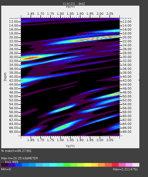
| Estimated Moho Depth: |
20.25 km |
| Estimated Crust Vp/Vs: |
1.99 |
| Assumed Crust Vp: |
6.048 km/s |
| Estimated Crust Vs: |
3.047 km/s |
| Estimated Crust Poisson's Ratio: |
0.33 |
|
| Radial Match: |
89.27391 % |
| Radial Bump: |
400 |
| Transverse Match: |
75.85107 % |
| Transverse Bump: |
400 |
| SOD ConfigId: |
414626 |
| Insert Time: |
2012-01-18 06:51:02.949 +0000 |
| GWidth: |
2.5 |
| Max Bumps: |
400 |
| Tol: |
0.001 |
|

Signal To Noise
| Channel | StoN | STA | LTA |
| CI:SCZ2: :BHZ:20110902T11:03:04.320011Z | 10.771166 | 4.687215E-6 | 4.3516323E-7 |
| CI:SCZ2: :BHN:20110902T11:03:04.320011Z | 2.981167 | 2.8773661E-6 | 9.651811E-7 |
| CI:SCZ2: :BHE:20110902T11:03:04.320011Z | 2.3157587 | 2.2114323E-6 | 9.549493E-7 |
| Arrivals |
| Ps | 3.5 SECOND |
| PpPs | 9.5 SECOND |
| PsPs/PpSs | 13 SECOND |


