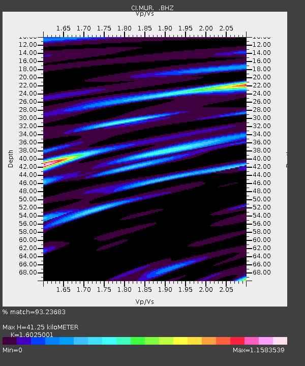
MUR Murrieta - Earthquake Result Viewer

Earthquake location: Fox Islands, Aleutian Islands
Earthquake latitude/longitude: 52.2/-171.7
Earthquake time(UTC): 2011/09/02 (245) 10:55:53 GMT
Earthquake Depth: 32 km
Earthquake Magnitude: 6.5 MB, 6.9 MS, 6.8 MW, 6.8 MW
Earthquake Catalog/Contributor: WHDF/NEIC
Network: CI Caltech Regional Seismic Network
Station: MUR Murrieta
Lat/Lon: 33.60 N/117.20 W
Elevation: 562 m
Distance: 42.9 deg
Az: 93.578 deg
Baz: 312.569 deg
Ray Param: 0.0728224
Estimated Moho Depth: 41.25 km
Estimated Crust Vp/Vs: 1.60
Assumed Crust Vp: 6.264 km/s
Estimated Crust Vs: 3.909 km/s
Estimated Crust Poisson's Ratio: 0.18
Radial Match: 93.23683 %
Radial Bump: 400
Transverse Match: 82.51177 %
Transverse Bump: 400
SOD ConfigId: 414626
Insert Time: 2012-01-18 06:51:18.079 +0000
GWidth: 2.5
Max Bumps: 400
Tol: 0.001

Signal To Noise

ChannelStoNSTALTA
CI:MUR: :BHZ:20110902T11:03:18.695011Z10.2739583.582927E-63.4873872E-7
CI:MUR: :BHN:20110902T11:03:18.695011Z7.50849771.809892E-62.4104583E-7
CI:MUR: :BHE:20110902T11:03:18.695011Z10.0916881.5925051E-61.5780364E-7
Arrivals
Ps4.3 SECOND
PpPs16 SECOND
PsPs/PpSs20 SECOND