FRB Iqaluit, Nunavut Territory, Canada - Earthquake Result Viewer
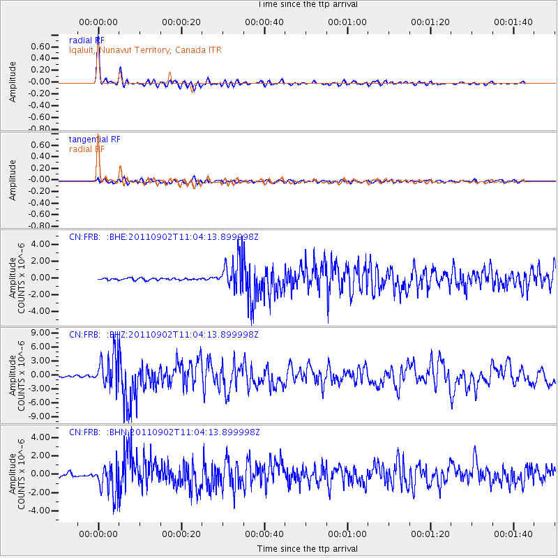
Earthquake location: Fox Islands, Aleutian Islands
Earthquake latitude/longitude: 52.2/-171.7
Earthquake time(UTC): 2011/09/02 (245) 10:55:53 GMT
Earthquake Depth: 32 km
Earthquake Magnitude: 6.5 MB, 6.9 MS, 6.8 MW, 6.8 MW
Earthquake Catalog/Contributor: WHDF/NEIC
Network: CN Canadian National Seismograph Network
Station: FRB Iqaluit, Nunavut Territory, Canada
Lat/Lon: 63.75 N/68.55 W
Elevation: 25 m
Distance: 50.0 deg
Az: 34.444 deg
Baz: 308.44 deg
Ray Param: 0.06830701
Estimated Moho Depth: 45.25 km
Estimated Crust Vp/Vs: 1.72
Assumed Crust Vp: 6.419 km/s
Estimated Crust Vs: 3.743 km/s
Estimated Crust Poisson's Ratio: 0.24
Radial Match: 95.815414 %
Radial Bump: 350
Transverse Match: 80.06692 %
Transverse Bump: 400
SOD ConfigId: 414626
Insert Time: 2012-01-18 06:51:54.868 +0000
GWidth: 2.5
Max Bumps: 400
Tol: 0.001

Signal To Noise

ChannelStoNSTALTA
CN:FRB: :BHZ:20110902T11:04:13.899998Z18.5220033.6625904E-61.9774266E-7
CN:FRB: :BHN:20110902T11:04:13.899998Z8.4688911.6541485E-61.9532054E-7
CN:FRB: :BHE:20110902T11:04:13.899998Z17.0840511.8308117E-61.0716496E-7
Arrivals
Ps5.4 SECOND
PpPs18 SECOND
PsPs/PpSs23 SECOND