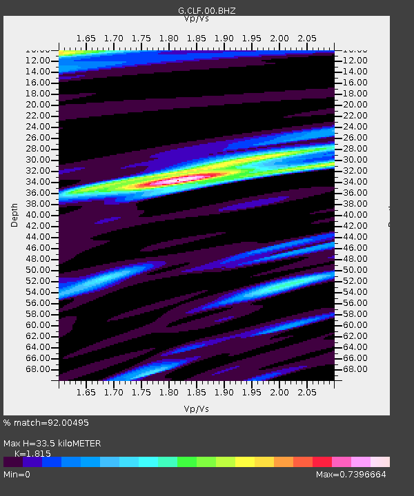
CLF Chambon la Foret observatory, France - Earthquake Result Viewer
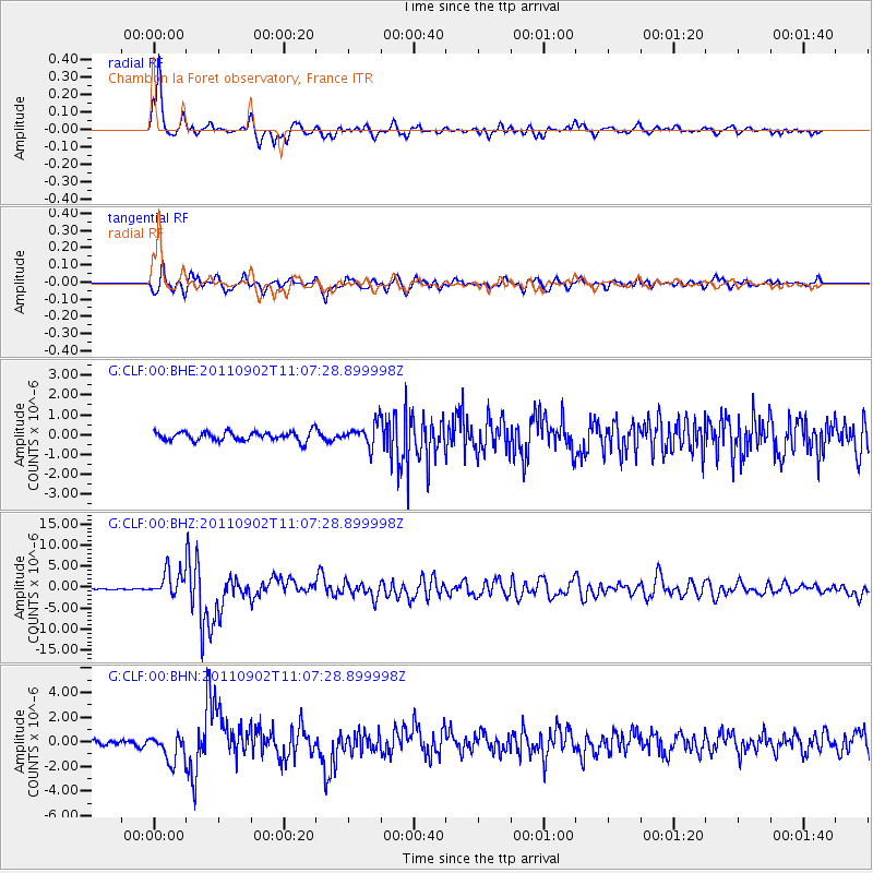
Earthquake location: Fox Islands, Aleutian Islands
Earthquake latitude/longitude: 52.2/-171.7
Earthquake time(UTC): 2011/09/02 (245) 10:55:53 GMT
Earthquake Depth: 32 km
Earthquake Magnitude: 6.5 MB, 6.9 MS, 6.8 MW, 6.8 MW
Earthquake Catalog/Contributor: WHDF/NEIC
Network: G GEOSCOPE
Station: CLF Chambon la Foret observatory, France
Lat/Lon: 48.03 N/2.26 E
Elevation: 145 m
Distance: 80.0 deg
Az: 4.107 deg
Baz: 356.233 deg
Ray Param: 0.048500188
Estimated Moho Depth: 33.5 km
Estimated Crust Vp/Vs: 1.82
Assumed Crust Vp: 6.12 km/s
Estimated Crust Vs: 3.372 km/s
Estimated Crust Poisson's Ratio: 0.28
Radial Match: 92.00495 %
Radial Bump: 344
Transverse Match: 84.47497 %
Transverse Bump: 400
SOD ConfigId: 414626
Insert Time: 2012-01-18 06:52:53.060 +0000
GWidth: 2.5
Max Bumps: 400
Tol: 0.001

Signal To Noise

ChannelStoNSTALTA
G:CLF:00:BHZ:20110902T11:07:28.899998Z18.1864743.1046854E-61.7071399E-7
G:CLF:00:BHN:20110902T11:07:28.899998Z4.91644051.1072428E-62.2521228E-7
G:CLF:00:BHE:20110902T11:07:28.899998Z2.33978755.479717E-72.3419722E-7
Arrivals
Ps4.6 SECOND
PpPs15 SECOND
PsPs/PpSs20 SECOND