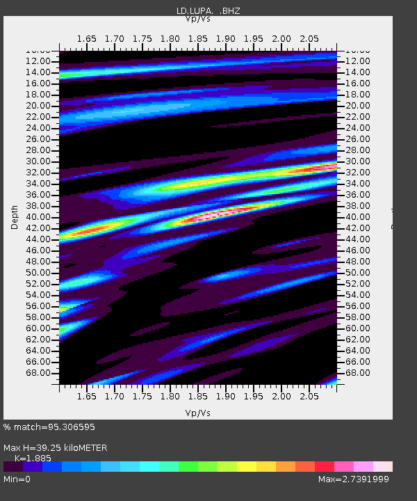
LUPA Lehigh University, PA - Earthquake Result Viewer
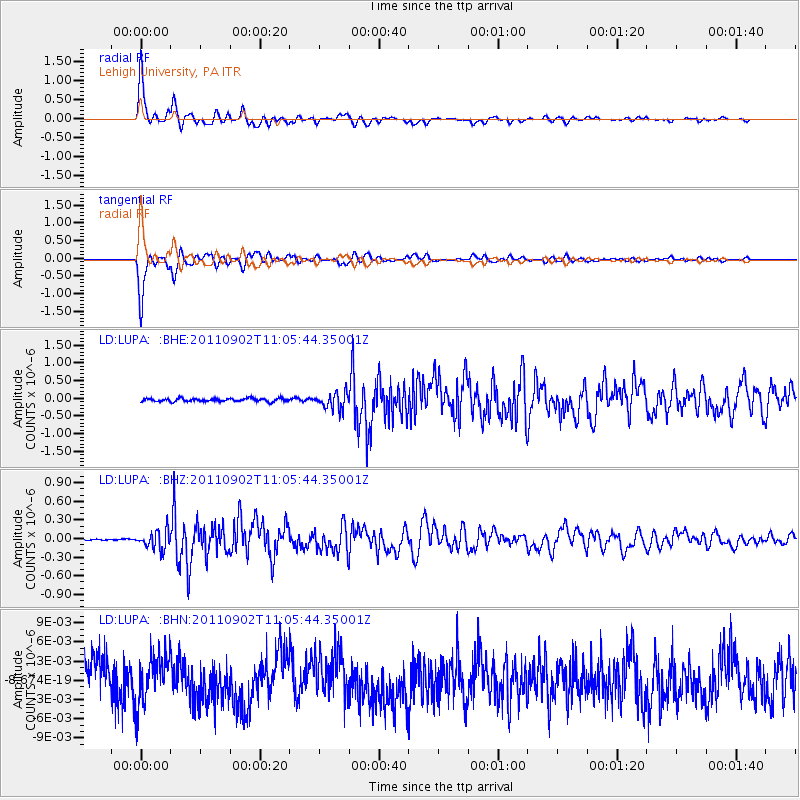
Earthquake location: Fox Islands, Aleutian Islands
Earthquake latitude/longitude: 52.2/-171.7
Earthquake time(UTC): 2011/09/02 (245) 10:55:53 GMT
Earthquake Depth: 32 km
Earthquake Magnitude: 6.5 MB, 6.9 MS, 6.8 MW, 6.8 MW
Earthquake Catalog/Contributor: WHDF/NEIC
Network: LD Lamont-Doherty Cooperative Seismographic Network
Station: LUPA Lehigh University, PA
Lat/Lon: 40.60 N/75.37 W
Elevation: 236 m
Distance: 62.7 deg
Az: 58.408 deg
Baz: 316.452 deg
Ray Param: 0.0600157
Estimated Moho Depth: 39.25 km
Estimated Crust Vp/Vs: 1.88
Assumed Crust Vp: 6.283 km/s
Estimated Crust Vs: 3.333 km/s
Estimated Crust Poisson's Ratio: 0.30
Radial Match: 95.306595 %
Radial Bump: 370
Transverse Match: 95.32709 %
Transverse Bump: 365
SOD ConfigId: 414626
Insert Time: 2012-01-18 06:58:02.122 +0000
GWidth: 2.5
Max Bumps: 400
Tol: 0.001

Signal To Noise

ChannelStoNSTALTA
LD:LUPA: :BHZ:20110902T11:05:44.35001Z17.9385031.4919443E-78.316994E-9
LD:LUPA: :BHN:20110902T11:05:44.35001Z1.14916753.7076477E-93.226377E-9
LD:LUPA: :BHE:20110902T11:05:44.35001Z5.0647882.2624734E-74.4670642E-8
Arrivals
Ps5.8 SECOND
PpPs17 SECOND
PsPs/PpSs23 SECOND