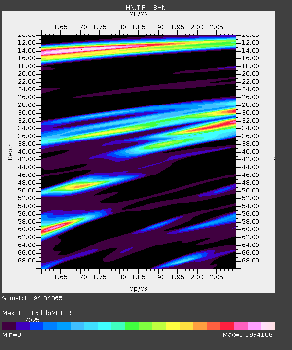
TIP Timpagrande, Italy - Earthquake Result Viewer
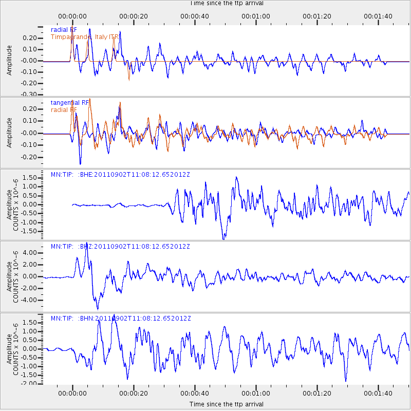
Earthquake location: Fox Islands, Aleutian Islands
Earthquake latitude/longitude: 52.2/-171.7
Earthquake time(UTC): 2011/09/02 (245) 10:55:53 GMT
Earthquake Depth: 32 km
Earthquake Magnitude: 6.5 MB, 6.9 MS, 6.8 MW, 6.8 MW
Earthquake Catalog/Contributor: WHDF/NEIC
Network: MN MEDNET Project
Station: TIP Timpagrande, Italy
Lat/Lon: 39.18 N/16.76 E
Elevation: 789 m
Distance: 88.7 deg
Az: 353.428 deg
Baz: 5.204 deg
Ray Param: 0.042331737
Estimated Moho Depth: 13.5 km
Estimated Crust Vp/Vs: 1.70
Assumed Crust Vp: 6.1 km/s
Estimated Crust Vs: 3.583 km/s
Estimated Crust Poisson's Ratio: 0.24
Radial Match: 94.34865 %
Radial Bump: 400
Transverse Match: 90.38791 %
Transverse Bump: 400
SOD ConfigId: 414626
Insert Time: 2012-01-18 07:00:18.680 +0000
GWidth: 2.5
Max Bumps: 400
Tol: 0.001

Signal To Noise

ChannelStoNSTALTA
MN:TIP: :BHZ:20110902T11:08:12.652012Z36.9440962.3767282E-66.43331E-8
MN:TIP: :BHN:20110902T11:08:12.652012Z11.9569564.7205955E-73.947991E-8
MN:TIP: :BHE:20110902T11:08:12.652012Z7.9675123.4741544E-74.3604004E-8
Arrivals
Ps1.6 SECOND
PpPs5.9 SECOND
PsPs/PpSs7.4 SECOND