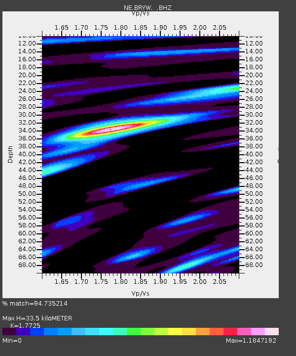
BRYW Smithfield, RI - Earthquake Result Viewer

Earthquake location: Fox Islands, Aleutian Islands
Earthquake latitude/longitude: 52.2/-171.7
Earthquake time(UTC): 2011/09/02 (245) 10:55:53 GMT
Earthquake Depth: 32 km
Earthquake Magnitude: 6.5 MB, 6.9 MS, 6.8 MW, 6.8 MW
Earthquake Catalog/Contributor: WHDF/NEIC
Network: NE New England Seismic Network
Station: BRYW Smithfield, RI
Lat/Lon: 41.92 N/71.54 W
Elevation: 107 m
Distance: 63.7 deg
Az: 55.034 deg
Baz: 317.449 deg
Ray Param: 0.05936058
Estimated Moho Depth: 33.5 km
Estimated Crust Vp/Vs: 1.77
Assumed Crust Vp: 6.472 km/s
Estimated Crust Vs: 3.651 km/s
Estimated Crust Poisson's Ratio: 0.27
Radial Match: 94.735214 %
Radial Bump: 327
Transverse Match: 73.06978 %
Transverse Bump: 400
SOD ConfigId: 414626
Insert Time: 2012-01-18 07:01:41.923 +0000
GWidth: 2.5
Max Bumps: 400
Tol: 0.001

Signal To Noise

ChannelStoNSTALTA
NE:BRYW: :BHZ:20110902T11:05:51.040012Z7.66329771.0896536E-61.4219121E-7
NE:BRYW: :BHN:20110902T11:05:51.040012Z3.58812174.7301964E-71.3182932E-7
NE:BRYW: :BHE:20110902T11:05:51.040012Z2.31785273.2507276E-71.4024737E-7
Arrivals
Ps4.2 SECOND
PpPs14 SECOND
PsPs/PpSs18 SECOND