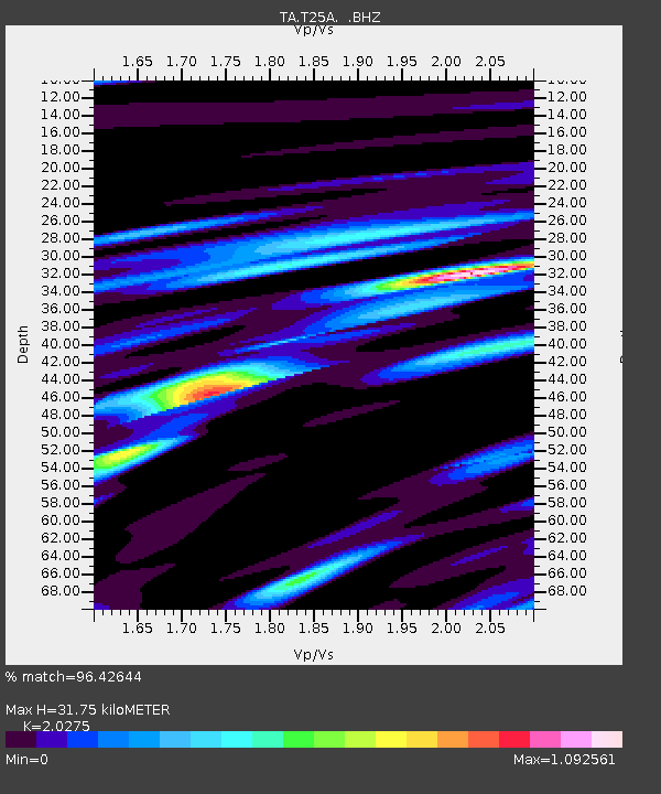
T25A Trinidad, CO, USA - Earthquake Result Viewer

Earthquake location: Fox Islands, Aleutian Islands
Earthquake latitude/longitude: 52.2/-171.7
Earthquake time(UTC): 2011/09/02 (245) 10:55:53 GMT
Earthquake Depth: 32 km
Earthquake Magnitude: 6.5 MB, 6.9 MS, 6.8 MW, 6.8 MW
Earthquake Catalog/Contributor: WHDF/NEIC
Network: TA USArray Transportable Network (new EarthScope stations)
Station: T25A Trinidad, CO, USA
Lat/Lon: 37.14 N/104.41 W
Elevation: 2017 m
Distance: 48.4 deg
Az: 80.206 deg
Baz: 310.583 deg
Ray Param: 0.069306545
Estimated Moho Depth: 31.75 km
Estimated Crust Vp/Vs: 2.03
Assumed Crust Vp: 6.316 km/s
Estimated Crust Vs: 3.115 km/s
Estimated Crust Poisson's Ratio: 0.34
Radial Match: 96.42644 %
Radial Bump: 385
Transverse Match: 92.13084 %
Transverse Bump: 400
SOD ConfigId: 414626
Insert Time: 2012-01-18 07:05:19.955 +0000
GWidth: 2.5
Max Bumps: 400
Tol: 0.001

Signal To Noise

ChannelStoNSTALTA
TA:T25A: :BHZ:20110902T11:04:02.174991Z24.765333.8294525E-61.5462957E-7
TA:T25A: :BHN:20110902T11:04:02.174991Z9.9708881.2677544E-61.2714558E-7
TA:T25A: :BHE:20110902T11:04:02.174991Z14.8091381.0637091E-67.1827884E-8
Arrivals
Ps5.4 SECOND
PpPs14 SECOND
PsPs/PpSs20 SECOND