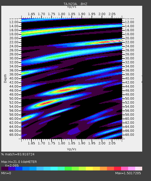
N23A Red Feather Lakes, CO, USA - Earthquake Result Viewer
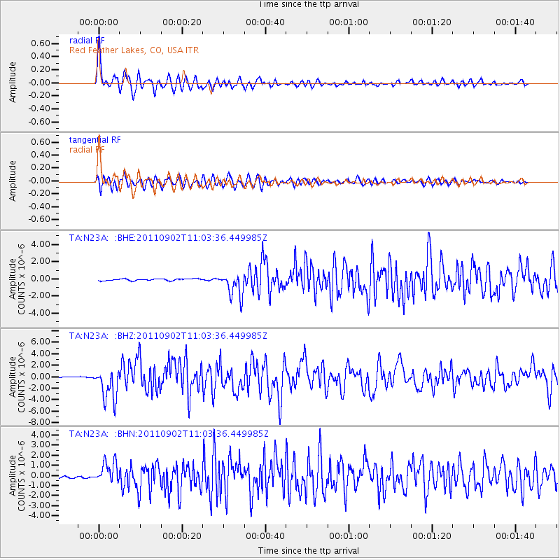
Earthquake location: Fox Islands, Aleutian Islands
Earthquake latitude/longitude: 52.2/-171.7
Earthquake time(UTC): 2011/09/02 (245) 10:55:53 GMT
Earthquake Depth: 32 km
Earthquake Magnitude: 6.5 MB, 6.9 MS, 6.8 MW, 6.8 MW
Earthquake Catalog/Contributor: WHDF/NEIC
Network: TA USArray Transportable Network (new EarthScope stations)
Station: N23A Red Feather Lakes, CO, USA
Lat/Lon: 40.89 N/105.94 W
Elevation: 2458 m
Distance: 45.1 deg
Az: 77.245 deg
Baz: 307.593 deg
Ray Param: 0.07141398
Estimated Moho Depth: 21.0 km
Estimated Crust Vp/Vs: 2.09
Assumed Crust Vp: 6.306 km/s
Estimated Crust Vs: 3.024 km/s
Estimated Crust Poisson's Ratio: 0.35
Radial Match: 93.918724 %
Radial Bump: 400
Transverse Match: 80.91253 %
Transverse Bump: 400
SOD ConfigId: 414626
Insert Time: 2012-01-18 07:05:39.169 +0000
GWidth: 2.5
Max Bumps: 400
Tol: 0.001

Signal To Noise

ChannelStoNSTALTA
TA:N23A: :BHZ:20110902T11:03:36.449985Z27.7277852.9092466E-61.0492171E-7
TA:N23A: :BHN:20110902T11:03:36.449985Z13.7055261.0924487E-67.970863E-8
TA:N23A: :BHE:20110902T11:03:36.449985Z13.597991.4518394E-61.06768674E-7
Arrivals
Ps3.8 SECOND
PpPs9.8 SECOND
PsPs/PpSs14 SECOND