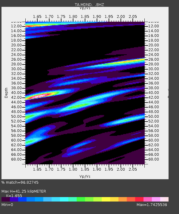
MDND Maddock, ND, USA - Earthquake Result Viewer
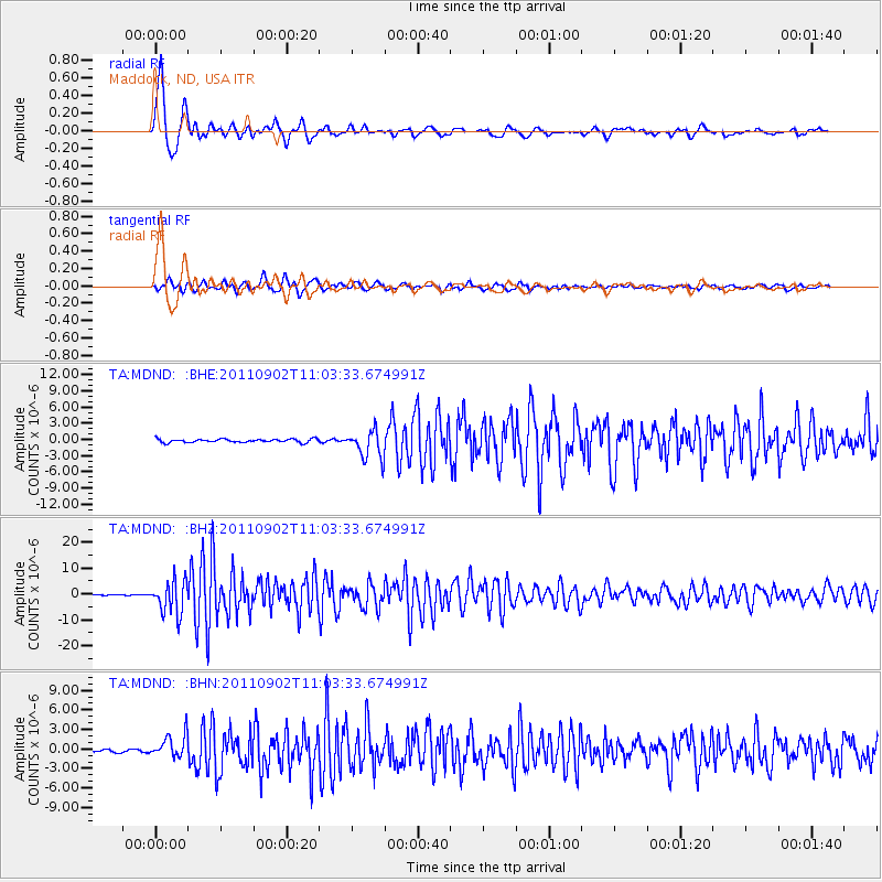
Earthquake location: Fox Islands, Aleutian Islands
Earthquake latitude/longitude: 52.2/-171.7
Earthquake time(UTC): 2011/09/02 (245) 10:55:53 GMT
Earthquake Depth: 32 km
Earthquake Magnitude: 6.5 MB, 6.9 MS, 6.8 MW, 6.8 MW
Earthquake Catalog/Contributor: WHDF/NEIC
Network: TA USArray Transportable Network (new EarthScope stations)
Station: MDND Maddock, ND, USA
Lat/Lon: 47.85 N/99.60 W
Elevation: 479 m
Distance: 44.8 deg
Az: 65.498 deg
Baz: 303.695 deg
Ray Param: 0.07164347
Estimated Moho Depth: 41.25 km
Estimated Crust Vp/Vs: 1.65
Assumed Crust Vp: 6.53 km/s
Estimated Crust Vs: 3.946 km/s
Estimated Crust Poisson's Ratio: 0.21
Radial Match: 96.82745 %
Radial Bump: 395
Transverse Match: 94.095726 %
Transverse Bump: 400
SOD ConfigId: 414626
Insert Time: 2012-01-18 07:05:53.078 +0000
GWidth: 2.5
Max Bumps: 400
Tol: 0.001

Signal To Noise

ChannelStoNSTALTA
TA:MDND: :BHZ:20110902T11:03:33.674991Z60.959486.4675874E-61.060965E-7
TA:MDND: :BHN:20110902T11:03:33.674991Z9.19059851.7739487E-61.9301775E-7
TA:MDND: :BHE:20110902T11:03:33.674991Z8.5970582.631685E-63.0611457E-7
Arrivals
Ps4.4 SECOND
PpPs16 SECOND
PsPs/PpSs20 SECOND