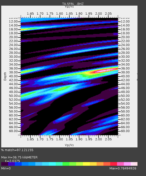
SFIN Lafayette, IN, USA - Earthquake Result Viewer

Earthquake location: Fox Islands, Aleutian Islands
Earthquake latitude/longitude: 52.2/-171.7
Earthquake time(UTC): 2011/09/02 (245) 10:55:53 GMT
Earthquake Depth: 32 km
Earthquake Magnitude: 6.5 MB, 6.9 MS, 6.8 MW, 6.8 MW
Earthquake Catalog/Contributor: WHDF/NEIC
Network: TA USArray Transportable Network (new EarthScope stations)
Station: SFIN Lafayette, IN, USA
Lat/Lon: 40.38 N/87.10 W
Elevation: 165 m
Distance: 56.5 deg
Az: 65.856 deg
Baz: 312.635 deg
Ray Param: 0.06407476
Estimated Moho Depth: 36.75 km
Estimated Crust Vp/Vs: 2.04
Assumed Crust Vp: 6.498 km/s
Estimated Crust Vs: 3.189 km/s
Estimated Crust Poisson's Ratio: 0.34
Radial Match: 97.121155 %
Radial Bump: 323
Transverse Match: 87.62239 %
Transverse Bump: 400
SOD ConfigId: 414626
Insert Time: 2012-01-18 07:06:05.891 +0000
GWidth: 2.5
Max Bumps: 400
Tol: 0.001

Signal To Noise

ChannelStoNSTALTA
TA:SFIN: :BHZ:20110902T11:05:01.550022Z45.649123.6246277E-67.940192E-8
TA:SFIN: :BHN:20110902T11:05:01.550022Z14.6435461.0497323E-67.168566E-8
TA:SFIN: :BHE:20110902T11:05:01.550022Z13.3322771.0280655E-67.711102E-8
Arrivals
Ps6.1 SECOND
PpPs16 SECOND
PsPs/PpSs23 SECOND