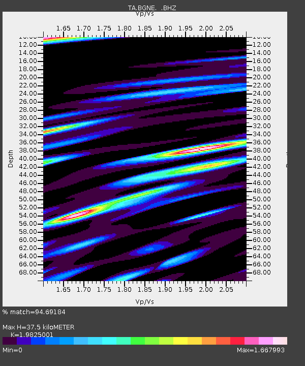
BGNE Belgrade, NE, USA - Earthquake Result Viewer
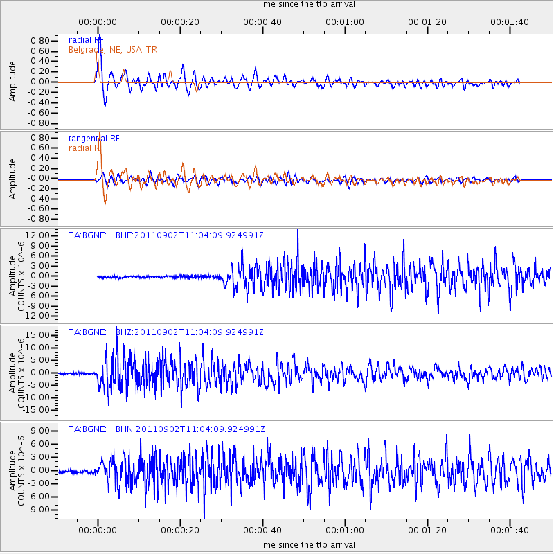
Earthquake location: Fox Islands, Aleutian Islands
Earthquake latitude/longitude: 52.2/-171.7
Earthquake time(UTC): 2011/09/02 (245) 10:55:53 GMT
Earthquake Depth: 32 km
Earthquake Magnitude: 6.5 MB, 6.9 MS, 6.8 MW, 6.8 MW
Earthquake Catalog/Contributor: WHDF/NEIC
Network: TA USArray Transportable Network (new EarthScope stations)
Station: BGNE Belgrade, NE, USA
Lat/Lon: 41.41 N/98.15 W
Elevation: 573 m
Distance: 49.4 deg
Az: 71.738 deg
Baz: 308.967 deg
Ray Param: 0.06864006
Estimated Moho Depth: 37.5 km
Estimated Crust Vp/Vs: 1.98
Assumed Crust Vp: 6.53 km/s
Estimated Crust Vs: 3.294 km/s
Estimated Crust Poisson's Ratio: 0.33
Radial Match: 94.69184 %
Radial Bump: 400
Transverse Match: 84.98814 %
Transverse Bump: 400
SOD ConfigId: 414626
Insert Time: 2012-01-18 07:06:10.724 +0000
GWidth: 2.5
Max Bumps: 400
Tol: 0.001

Signal To Noise

ChannelStoNSTALTA
TA:BGNE: :BHZ:20110902T11:04:09.924991Z26.7227635.9293893E-62.2188534E-7
TA:BGNE: :BHN:20110902T11:04:09.924991Z6.68232251.995128E-62.9856804E-7
TA:BGNE: :BHE:20110902T11:04:09.924991Z10.1839882.3280206E-62.2859616E-7
Arrivals
Ps6.0 SECOND
PpPs16 SECOND
PsPs/PpSs22 SECOND