You are here: Home > Network List > TA - USArray Transportable Network (new EarthScope stations) Stations List
> Station I48A Sherman Twp, MI, USA > Earthquake Result Viewer
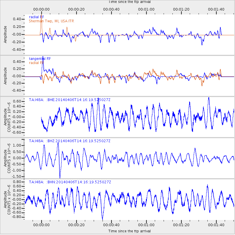
I48A Sherman Twp, MI, USA - Earthquake Result Viewer
*The percent match for this event was below the threshold and hence no stack was calculated.
| Earthquake location: |
Near Coast Of Northern Chile |
| Earthquake latitude/longitude: |
-20.4/-71.0 |
| Earthquake time(UTC): |
2014/04/06 (096) 14:06:09 GMT |
| Earthquake Depth: |
20 km |
| Earthquake Magnitude: |
5.3 MW |
| Earthquake Catalog/Contributor: |
ISC/ISC |
|
| Network: |
TA USArray Transportable Network (new EarthScope stations) |
| Station: |
I48A Sherman Twp, MI, USA |
| Lat/Lon: |
44.19 N/83.70 W |
| Elevation: |
192 m |
|
| Distance: |
65.4 deg |
| Az: |
349.945 deg |
| Baz: |
166.843 deg |
| Ray Param: |
$rayparam |
*The percent match for this event was below the threshold and hence was not used in the summary stack. |
|
| Radial Match: |
55.90382 % |
| Radial Bump: |
400 |
| Transverse Match: |
64.492744 % |
| Transverse Bump: |
400 |
| SOD ConfigId: |
3390531 |
| Insert Time: |
2019-04-11 04:36:37.076 +0000 |
| GWidth: |
2.5 |
| Max Bumps: |
400 |
| Tol: |
0.001 |
|
Signal To Noise
| Channel | StoN | STA | LTA |
| TA:I48A: :BHZ:20140406T14:16:19.525027Z | 2.6016772 | 5.836976E-7 | 2.2435435E-7 |
| TA:I48A: :BHN:20140406T14:16:19.525027Z | 1.4708593 | 2.8251134E-7 | 1.9207229E-7 |
| TA:I48A: :BHE:20140406T14:16:19.525027Z | 1.880225 | 4.066785E-7 | 2.1629248E-7 |
| Arrivals |
| Ps | |
| PpPs | |
| PsPs/PpSs | |


