You are here: Home > Network List > TA - USArray Transportable Network (new EarthScope stations) Stations List
> Station U32A Winter Ranch, Mooreland, OK, USA > Earthquake Result Viewer
U32A Winter Ranch, Mooreland, OK, USA - Earthquake Result Viewer
| Earthquake location: |
Fox Islands, Aleutian Islands |
| Earthquake latitude/longitude: |
52.2/-171.7 |
| Earthquake time(UTC): |
2011/09/02 (245) 10:55:53 GMT |
| Earthquake Depth: |
32 km |
| Earthquake Magnitude: |
6.5 MB, 6.9 MS, 6.8 MW, 6.8 MW |
| Earthquake Catalog/Contributor: |
WHDF/NEIC |
|
| Network: |
TA USArray Transportable Network (new EarthScope stations) |
| Station: |
U32A Winter Ranch, Mooreland, OK, USA |
| Lat/Lon: |
36.38 N/99.00 W |
| Elevation: |
525 m |
|
| Distance: |
52.2 deg |
| Az: |
77.225 deg |
| Baz: |
311.903 deg |
| Ray Param: |
0.06685826 |
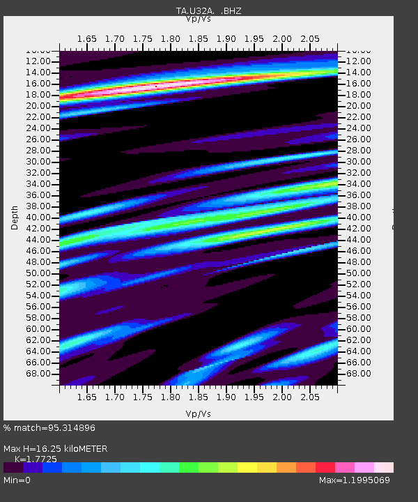
| Estimated Moho Depth: |
16.25 km |
| Estimated Crust Vp/Vs: |
1.77 |
| Assumed Crust Vp: |
6.426 km/s |
| Estimated Crust Vs: |
3.625 km/s |
| Estimated Crust Poisson's Ratio: |
0.27 |
|
| Radial Match: |
95.314896 % |
| Radial Bump: |
400 |
| Transverse Match: |
88.29304 % |
| Transverse Bump: |
400 |
| SOD ConfigId: |
414626 |
| Insert Time: |
2012-01-18 07:07:25.400 +0000 |
| GWidth: |
2.5 |
| Max Bumps: |
400 |
| Tol: |
0.001 |
|

Signal To Noise
| Channel | StoN | STA | LTA |
| TA:U32A: :BHZ:20110902T11:04:30.624973Z | 18.30058 | 3.1680072E-6 | 1.7310967E-7 |
| TA:U32A: :BHN:20110902T11:04:30.624973Z | 7.034825 | 9.3844244E-7 | 1.3339955E-7 |
| TA:U32A: :BHE:20110902T11:04:30.624973Z | 4.3344717 | 7.574766E-7 | 1.7475638E-7 |
| Arrivals |
| Ps | 2.1 SECOND |
| PpPs | 6.6 SECOND |
| PsPs/PpSs | 8.7 SECOND |


