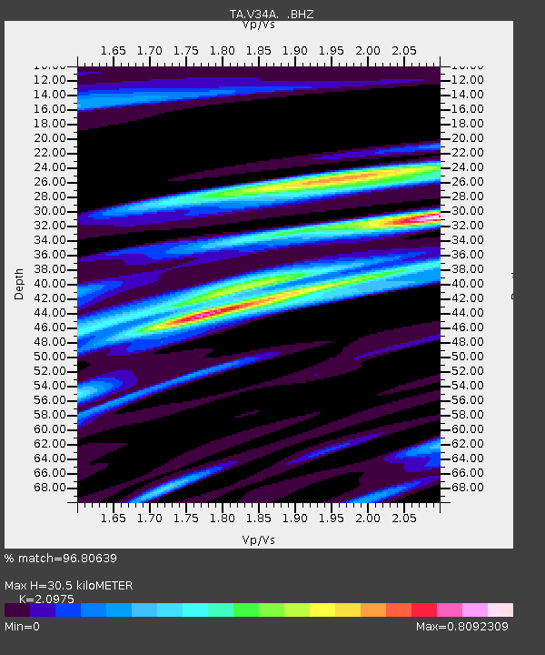
V34A Guthrie, OK, USA - Earthquake Result Viewer
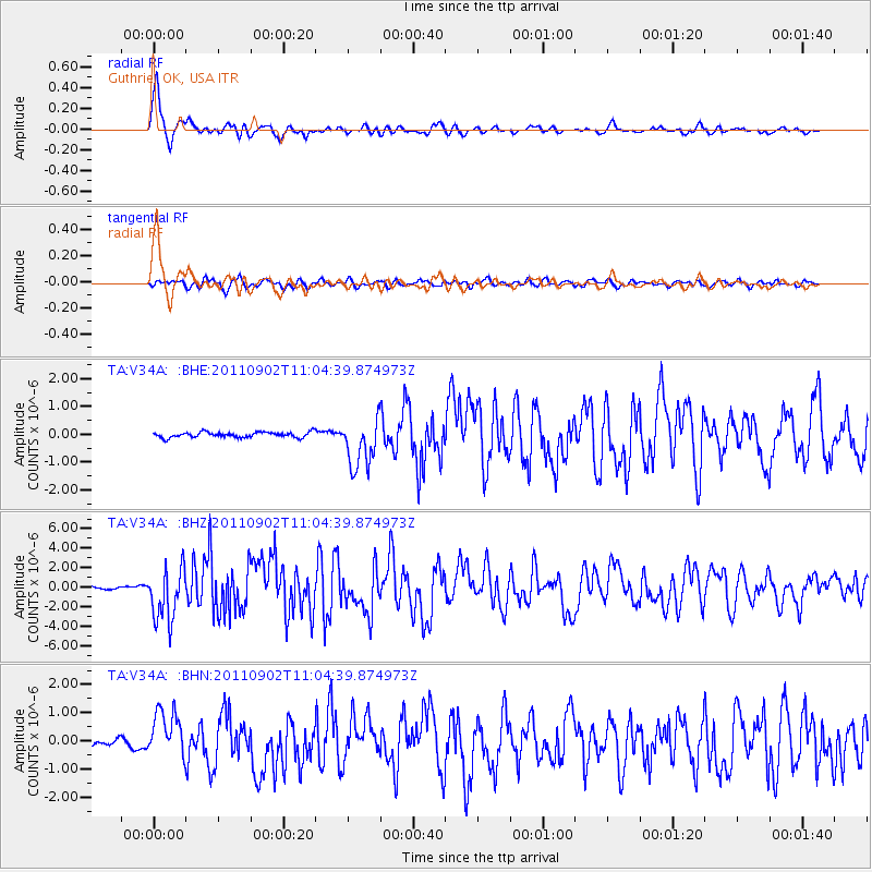
Earthquake location: Fox Islands, Aleutian Islands
Earthquake latitude/longitude: 52.2/-171.7
Earthquake time(UTC): 2011/09/02 (245) 10:55:53 GMT
Earthquake Depth: 32 km
Earthquake Magnitude: 6.5 MB, 6.9 MS, 6.8 MW, 6.8 MW
Earthquake Catalog/Contributor: WHDF/NEIC
Network: TA USArray Transportable Network (new EarthScope stations)
Station: V34A Guthrie, OK, USA
Lat/Lon: 35.83 N/97.52 W
Elevation: 329 m
Distance: 53.4 deg
Az: 76.718 deg
Baz: 312.468 deg
Ray Param: 0.066033125
Estimated Moho Depth: 30.5 km
Estimated Crust Vp/Vs: 2.10
Assumed Crust Vp: 6.426 km/s
Estimated Crust Vs: 3.064 km/s
Estimated Crust Poisson's Ratio: 0.35
Radial Match: 96.80639 %
Radial Bump: 376
Transverse Match: 79.084816 %
Transverse Bump: 400
SOD ConfigId: 414626
Insert Time: 2012-01-18 07:07:59.524 +0000
GWidth: 2.5
Max Bumps: 400
Tol: 0.001

Signal To Noise

ChannelStoNSTALTA
TA:V34A: :BHZ:20110902T11:04:39.874973Z17.2340892.7291005E-61.583548E-7
TA:V34A: :BHN:20110902T11:04:39.874973Z5.820628.4157284E-71.4458475E-7
TA:V34A: :BHE:20110902T11:04:39.874973Z9.3309178.893784E-79.5315215E-8
Arrivals
Ps5.5 SECOND
PpPs14 SECOND
PsPs/PpSs19 SECOND