You are here: Home > Network List > TA - USArray Transportable Network (new EarthScope stations) Stations List
> Station Z41A Richland Creek Farm, El Dorado, AR, USA > Earthquake Result Viewer
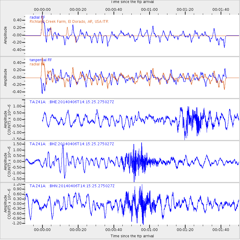
Z41A Richland Creek Farm, El Dorado, AR, USA - Earthquake Result Viewer
*The percent match for this event was below the threshold and hence no stack was calculated.
| Earthquake location: |
Near Coast Of Northern Chile |
| Earthquake latitude/longitude: |
-20.4/-71.0 |
| Earthquake time(UTC): |
2014/04/06 (096) 14:06:09 GMT |
| Earthquake Depth: |
20 km |
| Earthquake Magnitude: |
5.3 MW |
| Earthquake Catalog/Contributor: |
ISC/ISC |
|
| Network: |
TA USArray Transportable Network (new EarthScope stations) |
| Station: |
Z41A Richland Creek Farm, El Dorado, AR, USA |
| Lat/Lon: |
33.26 N/92.80 W |
| Elevation: |
62 m |
|
| Distance: |
57.3 deg |
| Az: |
338.258 deg |
| Baz: |
155.505 deg |
| Ray Param: |
$rayparam |
*The percent match for this event was below the threshold and hence was not used in the summary stack. |
|
| Radial Match: |
57.387077 % |
| Radial Bump: |
400 |
| Transverse Match: |
54.94405 % |
| Transverse Bump: |
400 |
| SOD ConfigId: |
3390531 |
| Insert Time: |
2019-04-11 04:37:26.560 +0000 |
| GWidth: |
2.5 |
| Max Bumps: |
400 |
| Tol: |
0.001 |
|
Signal To Noise
| Channel | StoN | STA | LTA |
| TA:Z41A: :BHZ:20140406T14:15:25.275027Z | 2.633328 | 4.1790312E-7 | 1.5869772E-7 |
| TA:Z41A: :BHN:20140406T14:15:25.275027Z | 0.83678985 | 2.3030134E-7 | 2.7522003E-7 |
| TA:Z41A: :BHE:20140406T14:15:25.275027Z | 1.2228688 | 3.7442135E-7 | 3.0618278E-7 |
| Arrivals |
| Ps | |
| PpPs | |
| PsPs/PpSs | |


