You are here: Home > Network List > TA - USArray Transportable Network (new EarthScope stations) Stations List
> Station 135A Vickery Place, Crowley, TX, USA > Earthquake Result Viewer
135A Vickery Place, Crowley, TX, USA - Earthquake Result Viewer
| Earthquake location: |
Fox Islands, Aleutian Islands |
| Earthquake latitude/longitude: |
52.2/-171.7 |
| Earthquake time(UTC): |
2011/09/02 (245) 10:55:53 GMT |
| Earthquake Depth: |
32 km |
| Earthquake Magnitude: |
6.5 MB, 6.9 MS, 6.8 MW, 6.8 MW |
| Earthquake Catalog/Contributor: |
WHDF/NEIC |
|
| Network: |
TA USArray Transportable Network (new EarthScope stations) |
| Station: |
135A Vickery Place, Crowley, TX, USA |
| Lat/Lon: |
32.56 N/97.41 W |
| Elevation: |
270 m |
|
| Distance: |
55.8 deg |
| Az: |
79.56 deg |
| Baz: |
314.175 deg |
| Ray Param: |
0.064529024 |
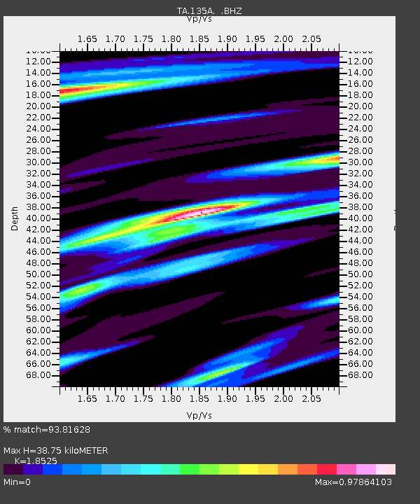
| Estimated Moho Depth: |
38.75 km |
| Estimated Crust Vp/Vs: |
1.85 |
| Assumed Crust Vp: |
6.38 km/s |
| Estimated Crust Vs: |
3.444 km/s |
| Estimated Crust Poisson's Ratio: |
0.29 |
|
| Radial Match: |
93.81628 % |
| Radial Bump: |
392 |
| Transverse Match: |
91.035446 % |
| Transverse Bump: |
400 |
| SOD ConfigId: |
414626 |
| Insert Time: |
2012-01-18 07:09:32.102 +0000 |
| GWidth: |
2.5 |
| Max Bumps: |
400 |
| Tol: |
0.001 |
|
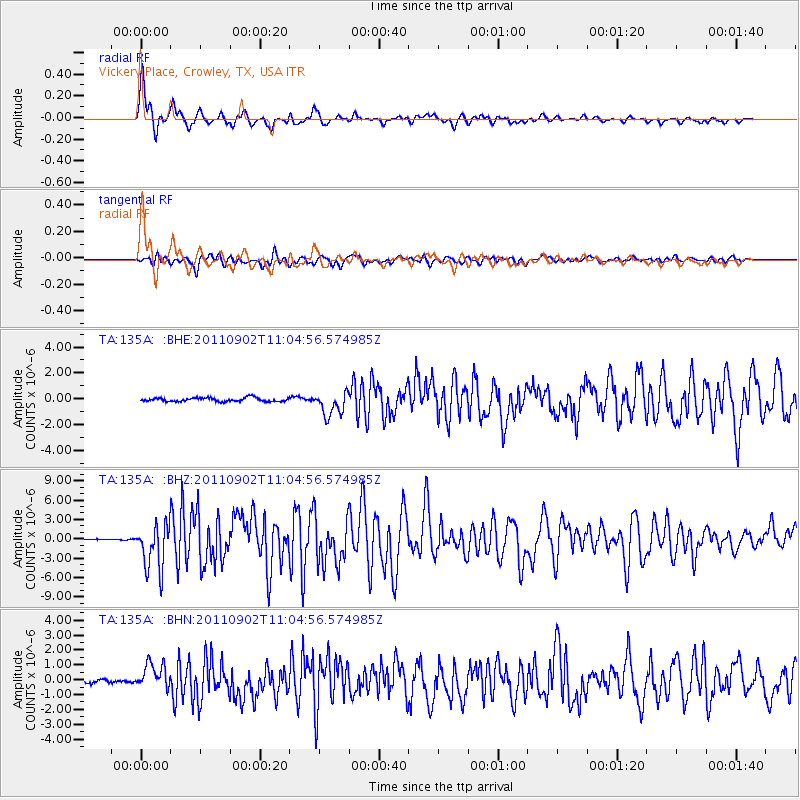
Signal To Noise
| Channel | StoN | STA | LTA |
| TA:135A: :BHZ:20110902T11:04:56.574985Z | 31.687328 | 3.5423907E-6 | 1.11792026E-7 |
| TA:135A: :BHN:20110902T11:04:56.574985Z | 10.266732 | 8.614766E-7 | 8.390952E-8 |
| TA:135A: :BHE:20110902T11:04:56.574985Z | 6.328278 | 9.1514096E-7 | 1.4461136E-7 |
| Arrivals |
| Ps | 5.4 SECOND |
| PpPs | 17 SECOND |
| PsPs/PpSs | 22 SECOND |


