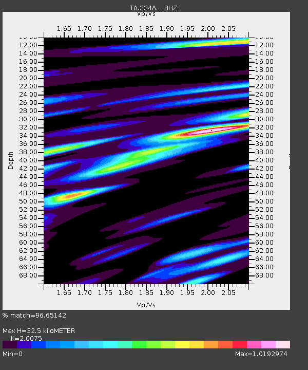
334A Lometa, TX, USA - Earthquake Result Viewer
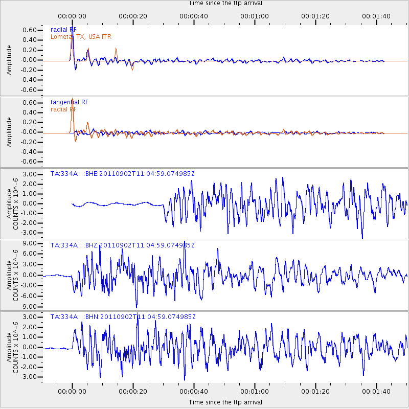
Earthquake location: Fox Islands, Aleutian Islands
Earthquake latitude/longitude: 52.2/-171.7
Earthquake time(UTC): 2011/09/02 (245) 10:55:53 GMT
Earthquake Depth: 32 km
Earthquake Magnitude: 6.5 MB, 6.9 MS, 6.8 MW, 6.8 MW
Earthquake Catalog/Contributor: WHDF/NEIC
Network: TA USArray Transportable Network (new EarthScope stations)
Station: 334A Lometa, TX, USA
Lat/Lon: 31.33 N/98.24 W
Elevation: 389 m
Distance: 56.1 deg
Az: 81.208 deg
Baz: 314.662 deg
Ray Param: 0.06430009
Estimated Moho Depth: 32.5 km
Estimated Crust Vp/Vs: 2.01
Assumed Crust Vp: 6.498 km/s
Estimated Crust Vs: 3.237 km/s
Estimated Crust Poisson's Ratio: 0.33
Radial Match: 96.65142 %
Radial Bump: 359
Transverse Match: 85.01641 %
Transverse Bump: 400
SOD ConfigId: 414626
Insert Time: 2012-01-18 07:09:44.802 +0000
GWidth: 2.5
Max Bumps: 400
Tol: 0.001

Signal To Noise

ChannelStoNSTALTA
TA:334A: :BHZ:20110902T11:04:59.074985Z22.571512.9346747E-61.3001676E-7
TA:334A: :BHN:20110902T11:04:59.074985Z21.5929931.033479E-64.7861775E-8
TA:334A: :BHE:20110902T11:04:59.074985Z8.2073519.993978E-71.2176864E-7
Arrivals
Ps5.3 SECOND
PpPs14 SECOND
PsPs/PpSs20 SECOND