335A Moody, TX, USA - Earthquake Result Viewer
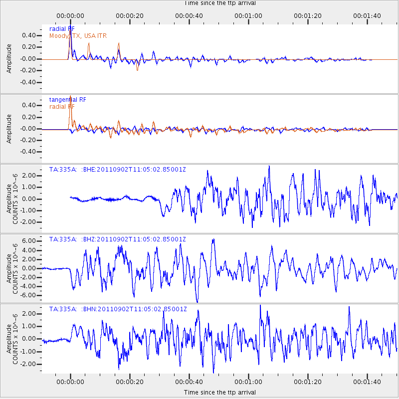
Earthquake location: Fox Islands, Aleutian Islands
Earthquake latitude/longitude: 52.2/-171.7
Earthquake time(UTC): 2011/09/02 (245) 10:55:53 GMT
Earthquake Depth: 32 km
Earthquake Magnitude: 6.5 MB, 6.9 MS, 6.8 MW, 6.8 MW
Earthquake Catalog/Contributor: WHDF/NEIC
Network: TA USArray Transportable Network (new EarthScope stations)
Station: 335A Moody, TX, USA
Lat/Lon: 31.28 N/97.43 W
Elevation: 217 m
Distance: 56.6 deg
Az: 80.665 deg
Baz: 314.78 deg
Ray Param: 0.06395527
Estimated Moho Depth: 42.0 km
Estimated Crust Vp/Vs: 1.60
Assumed Crust Vp: 6.347 km/s
Estimated Crust Vs: 3.967 km/s
Estimated Crust Poisson's Ratio: 0.18
Radial Match: 94.393555 %
Radial Bump: 400
Transverse Match: 87.26857 %
Transverse Bump: 400
SOD ConfigId: 414626
Insert Time: 2012-01-18 07:09:58.335 +0000
GWidth: 2.5
Max Bumps: 400
Tol: 0.001

Signal To Noise

ChannelStoNSTALTA
TA:335A: :BHZ:20110902T11:05:02.85001Z17.110072.4040328E-61.4050399E-7
TA:335A: :BHN:20110902T11:05:02.85001Z10.0857976.9888773E-76.929425E-8
TA:335A: :BHE:20110902T11:05:02.85001Z7.45689068.053515E-71.08000975E-7
Arrivals
Ps4.2 SECOND
PpPs16 SECOND
PsPs/PpSs20 SECOND