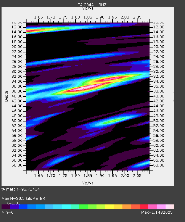
234A Clairette, TX, USA - Earthquake Result Viewer

Earthquake location: Fox Islands, Aleutian Islands
Earthquake latitude/longitude: 52.2/-171.7
Earthquake time(UTC): 2011/09/02 (245) 10:55:53 GMT
Earthquake Depth: 32 km
Earthquake Magnitude: 6.5 MB, 6.9 MS, 6.8 MW, 6.8 MW
Earthquake Catalog/Contributor: WHDF/NEIC
Network: TA USArray Transportable Network (new EarthScope stations)
Station: 234A Clairette, TX, USA
Lat/Lon: 32.00 N/98.14 W
Elevation: 358 m
Distance: 55.7 deg
Az: 80.558 deg
Baz: 314.35 deg
Ray Param: 0.06456539
Estimated Moho Depth: 36.5 km
Estimated Crust Vp/Vs: 1.83
Assumed Crust Vp: 6.426 km/s
Estimated Crust Vs: 3.512 km/s
Estimated Crust Poisson's Ratio: 0.29
Radial Match: 95.71434 %
Radial Bump: 400
Transverse Match: 88.40202 %
Transverse Bump: 400
SOD ConfigId: 414626
Insert Time: 2012-01-18 07:10:13.536 +0000
GWidth: 2.5
Max Bumps: 400
Tol: 0.001

Signal To Noise

ChannelStoNSTALTA
TA:234A: :BHZ:20110902T11:04:56.175022Z26.3645342.9746107E-61.12826214E-7
TA:234A: :BHN:20110902T11:04:56.175022Z4.86565079.2005166E-71.8909118E-7
TA:234A: :BHE:20110902T11:04:56.175022Z7.96090139.977524E-71.2533158E-7
Arrivals
Ps5.0 SECOND
PpPs15 SECOND
PsPs/PpSs20 SECOND