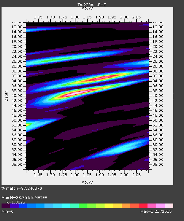
233A Rising Star, TX, USA - Earthquake Result Viewer

Earthquake location: Fox Islands, Aleutian Islands
Earthquake latitude/longitude: 52.2/-171.7
Earthquake time(UTC): 2011/09/02 (245) 10:55:53 GMT
Earthquake Depth: 32 km
Earthquake Magnitude: 6.5 MB, 6.9 MS, 6.8 MW, 6.8 MW
Earthquake Catalog/Contributor: WHDF/NEIC
Network: TA USArray Transportable Network (new EarthScope stations)
Station: 233A Rising Star, TX, USA
Lat/Lon: 32.02 N/98.90 W
Elevation: 539 m
Distance: 55.2 deg
Az: 81.096 deg
Baz: 314.253 deg
Ray Param: 0.06487367
Estimated Moho Depth: 38.75 km
Estimated Crust Vp/Vs: 1.80
Assumed Crust Vp: 6.426 km/s
Estimated Crust Vs: 3.565 km/s
Estimated Crust Poisson's Ratio: 0.28
Radial Match: 97.246376 %
Radial Bump: 368
Transverse Match: 88.56799 %
Transverse Bump: 400
SOD ConfigId: 414626
Insert Time: 2012-01-18 07:10:21.393 +0000
GWidth: 2.5
Max Bumps: 400
Tol: 0.001

Signal To Noise

ChannelStoNSTALTA
TA:233A: :BHZ:20110902T11:04:52.749973Z41.2927552.9587868E-67.16539E-8
TA:233A: :BHN:20110902T11:04:52.749973Z13.0792898.749788E-76.689804E-8
TA:233A: :BHE:20110902T11:04:52.749973Z8.5579881.0241837E-61.1967576E-7
Arrivals
Ps5.1 SECOND
PpPs16 SECOND
PsPs/PpSs21 SECOND