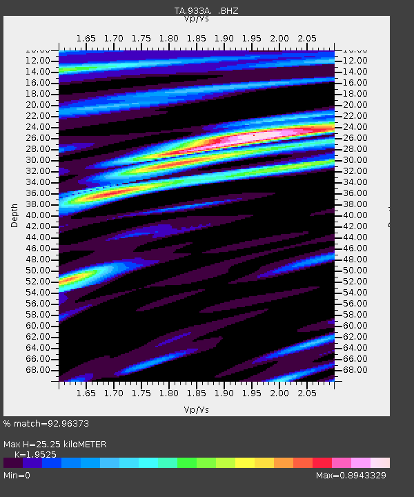
933A Laredo, TX, USA - Earthquake Result Viewer
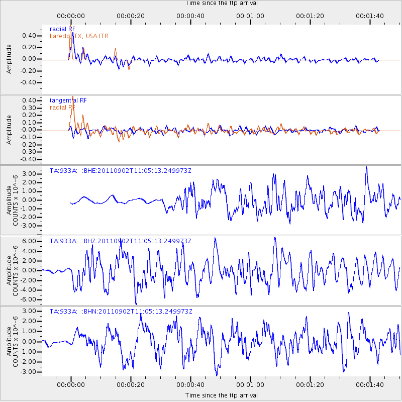
Earthquake location: Fox Islands, Aleutian Islands
Earthquake latitude/longitude: 52.2/-171.7
Earthquake time(UTC): 2011/09/02 (245) 10:55:53 GMT
Earthquake Depth: 32 km
Earthquake Magnitude: 6.5 MB, 6.9 MS, 6.8 MW, 6.8 MW
Earthquake Catalog/Contributor: WHDF/NEIC
Network: TA USArray Transportable Network (new EarthScope stations)
Station: 933A Laredo, TX, USA
Lat/Lon: 27.61 N/99.27 W
Elevation: 214 m
Distance: 58.1 deg
Az: 85.071 deg
Baz: 316.253 deg
Ray Param: 0.06299876
Estimated Moho Depth: 25.25 km
Estimated Crust Vp/Vs: 1.95
Assumed Crust Vp: 6.096 km/s
Estimated Crust Vs: 3.122 km/s
Estimated Crust Poisson's Ratio: 0.32
Radial Match: 92.96373 %
Radial Bump: 366
Transverse Match: 84.120125 %
Transverse Bump: 400
SOD ConfigId: 414626
Insert Time: 2012-01-18 07:11:39.117 +0000
GWidth: 2.5
Max Bumps: 400
Tol: 0.001

Signal To Noise

ChannelStoNSTALTA
TA:933A: :BHZ:20110902T11:05:13.249973Z10.9061462.3880434E-62.1896308E-7
TA:933A: :BHN:20110902T11:05:13.249973Z2.58402947.280395E-72.8174583E-7
TA:933A: :BHE:20110902T11:05:13.249973Z2.76990137.43059E-72.682619E-7
Arrivals
Ps4.1 SECOND
PpPs12 SECOND
PsPs/PpSs16 SECOND