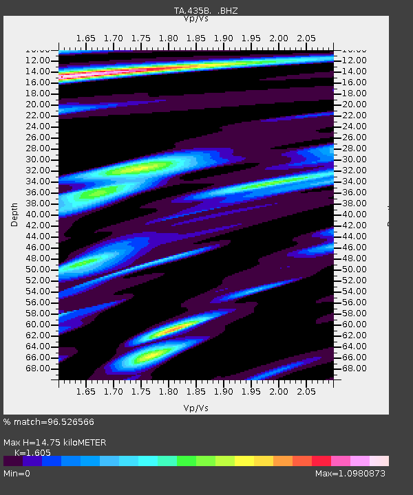
435B Jarrell, TX, USA - Earthquake Result Viewer

Earthquake location: Fox Islands, Aleutian Islands
Earthquake latitude/longitude: 52.2/-171.7
Earthquake time(UTC): 2011/09/02 (245) 10:55:53 GMT
Earthquake Depth: 32 km
Earthquake Magnitude: 6.5 MB, 6.9 MS, 6.8 MW, 6.8 MW
Earthquake Catalog/Contributor: WHDF/NEIC
Network: TA USArray Transportable Network (new EarthScope stations)
Station: 435B Jarrell, TX, USA
Lat/Lon: 30.78 N/97.58 W
Elevation: 248 m
Distance: 56.9 deg
Az: 81.2 deg
Baz: 314.993 deg
Ray Param: 0.06378774
Estimated Moho Depth: 14.75 km
Estimated Crust Vp/Vs: 1.61
Assumed Crust Vp: 6.347 km/s
Estimated Crust Vs: 3.955 km/s
Estimated Crust Poisson's Ratio: 0.18
Radial Match: 96.526566 %
Radial Bump: 400
Transverse Match: 87.20638 %
Transverse Bump: 400
SOD ConfigId: 414626
Insert Time: 2012-01-18 07:12:13.228 +0000
GWidth: 2.5
Max Bumps: 400
Tol: 0.001

Signal To Noise

ChannelStoNSTALTA
TA:435B: :BHZ:20110902T11:05:04.649998Z17.7491322.3578025E-61.3284044E-7
TA:435B: :BHN:20110902T11:05:04.649998Z7.0510028.766644E-71.2433189E-7
TA:435B: :BHE:20110902T11:05:04.649998Z6.190928.1543817E-71.3171518E-7
Arrivals
Ps1.5 SECOND
PpPs5.7 SECOND
PsPs/PpSs7.2 SECOND