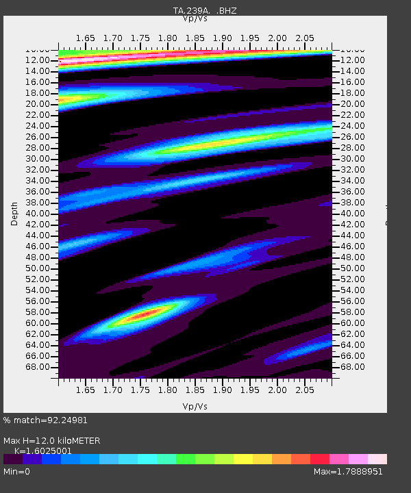
239A Gary, TX, USA - Earthquake Result Viewer
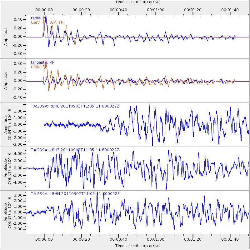
Earthquake location: Fox Islands, Aleutian Islands
Earthquake latitude/longitude: 52.2/-171.7
Earthquake time(UTC): 2011/09/02 (245) 10:55:53 GMT
Earthquake Depth: 32 km
Earthquake Magnitude: 6.5 MB, 6.9 MS, 6.8 MW, 6.8 MW
Earthquake Catalog/Contributor: WHDF/NEIC
Network: TA USArray Transportable Network (new EarthScope stations)
Station: 239A Gary, TX, USA
Lat/Lon: 32.02 N/94.47 W
Elevation: 100 m
Distance: 57.9 deg
Az: 77.934 deg
Baz: 314.847 deg
Ray Param: 0.06313402
Estimated Moho Depth: 12.0 km
Estimated Crust Vp/Vs: 1.60
Assumed Crust Vp: 6.245 km/s
Estimated Crust Vs: 3.897 km/s
Estimated Crust Poisson's Ratio: 0.18
Radial Match: 92.24981 %
Radial Bump: 400
Transverse Match: 85.7203 %
Transverse Bump: 400
SOD ConfigId: 414626
Insert Time: 2012-01-18 07:13:31.506 +0000
GWidth: 2.5
Max Bumps: 400
Tol: 0.001

Signal To Noise

ChannelStoNSTALTA
TA:239A: :BHZ:20110902T11:05:11.800022Z16.1141532.1293922E-61.3214421E-7
TA:239A: :BHN:20110902T11:05:11.800022Z3.2383366.407981E-71.9787882E-7
TA:239A: :BHE:20110902T11:05:11.800022Z3.17801886.4607184E-72.0329391E-7
Arrivals
Ps1.2 SECOND
PpPs4.8 SECOND
PsPs/PpSs6.0 SECOND