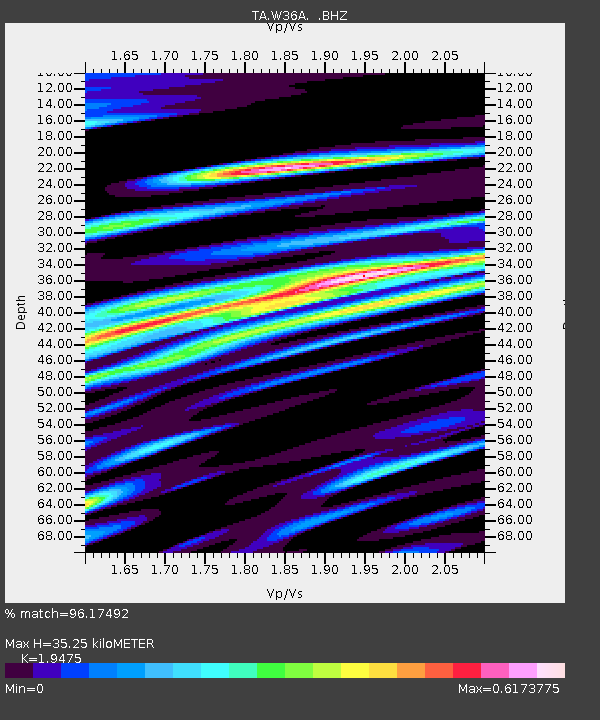
W36A Wetumka, OK, USA - Earthquake Result Viewer
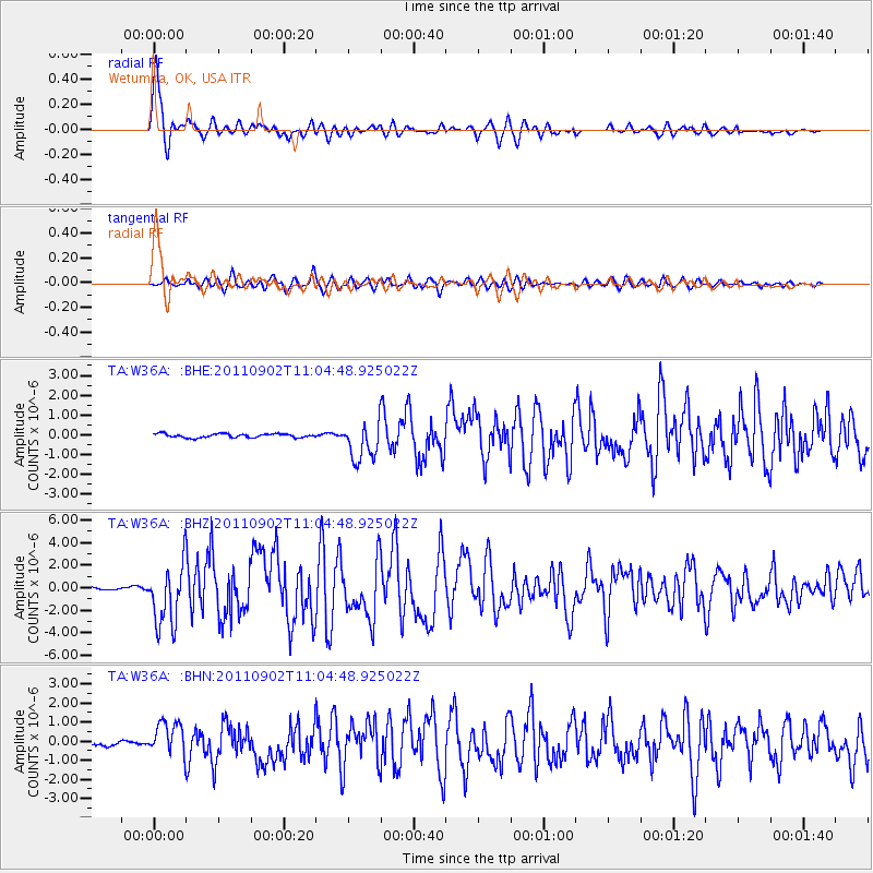
Earthquake location: Fox Islands, Aleutian Islands
Earthquake latitude/longitude: 52.2/-171.7
Earthquake time(UTC): 2011/09/02 (245) 10:55:53 GMT
Earthquake Depth: 32 km
Earthquake Magnitude: 6.5 MB, 6.9 MS, 6.8 MW, 6.8 MW
Earthquake Catalog/Contributor: WHDF/NEIC
Network: TA USArray Transportable Network (new EarthScope stations)
Station: W36A Wetumka, OK, USA
Lat/Lon: 35.14 N/96.23 W
Elevation: 251 m
Distance: 54.7 deg
Az: 76.463 deg
Baz: 313.064 deg
Ray Param: 0.06523044
Estimated Moho Depth: 35.25 km
Estimated Crust Vp/Vs: 1.95
Assumed Crust Vp: 6.426 km/s
Estimated Crust Vs: 3.3 km/s
Estimated Crust Poisson's Ratio: 0.32
Radial Match: 96.17492 %
Radial Bump: 390
Transverse Match: 85.999565 %
Transverse Bump: 400
SOD ConfigId: 414626
Insert Time: 2012-01-18 07:14:42.939 +0000
GWidth: 2.5
Max Bumps: 400
Tol: 0.001

Signal To Noise

ChannelStoNSTALTA
TA:W36A: :BHZ:20110902T11:04:48.925022Z27.8656232.715059E-69.7434004E-8
TA:W36A: :BHN:20110902T11:04:48.925022Z6.50704578.6148077E-71.3239199E-7
TA:W36A: :BHE:20110902T11:04:48.925022Z10.1542379.664595E-79.517797E-8
Arrivals
Ps5.5 SECOND
PpPs15 SECOND
PsPs/PpSs21 SECOND