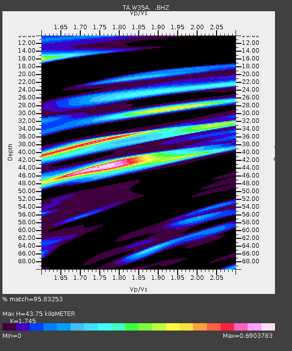
W35A Tecumseh, OK, USA - Earthquake Result Viewer

Earthquake location: Fox Islands, Aleutian Islands
Earthquake latitude/longitude: 52.2/-171.7
Earthquake time(UTC): 2011/09/02 (245) 10:55:53 GMT
Earthquake Depth: 32 km
Earthquake Magnitude: 6.5 MB, 6.9 MS, 6.8 MW, 6.8 MW
Earthquake Catalog/Contributor: WHDF/NEIC
Network: TA USArray Transportable Network (new EarthScope stations)
Station: W35A Tecumseh, OK, USA
Lat/Lon: 35.15 N/96.87 W
Elevation: 322 m
Distance: 54.3 deg
Az: 76.896 deg
Baz: 312.944 deg
Ray Param: 0.06548174
Estimated Moho Depth: 43.75 km
Estimated Crust Vp/Vs: 1.75
Assumed Crust Vp: 6.426 km/s
Estimated Crust Vs: 3.683 km/s
Estimated Crust Poisson's Ratio: 0.26
Radial Match: 95.83253 %
Radial Bump: 368
Transverse Match: 86.02647 %
Transverse Bump: 400
SOD ConfigId: 414626
Insert Time: 2012-01-18 07:14:43.493 +0000
GWidth: 2.5
Max Bumps: 400
Tol: 0.001

Signal To Noise

ChannelStoNSTALTA
TA:W35A: :BHZ:20110902T11:04:46.024998Z24.5090333.1924599E-61.3025645E-7
TA:W35A: :BHN:20110902T11:04:46.024998Z6.47954561.0693504E-61.6503478E-7
TA:W35A: :BHE:20110902T11:04:46.024998Z8.5572741.0498561E-61.2268582E-7
Arrivals
Ps5.4 SECOND
PpPs18 SECOND
PsPs/PpSs23 SECOND