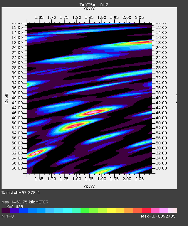
X35A Drake, OK, USA - Earthquake Result Viewer
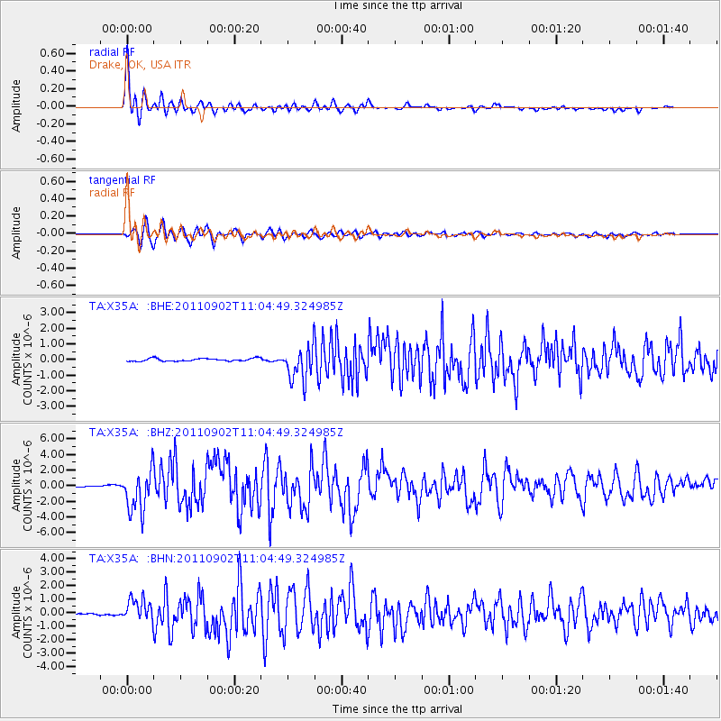
Earthquake location: Fox Islands, Aleutian Islands
Earthquake latitude/longitude: 52.2/-171.7
Earthquake time(UTC): 2011/09/02 (245) 10:55:53 GMT
Earthquake Depth: 32 km
Earthquake Magnitude: 6.5 MB, 6.9 MS, 6.8 MW, 6.8 MW
Earthquake Catalog/Contributor: WHDF/NEIC
Network: TA USArray Transportable Network (new EarthScope stations)
Station: X35A Drake, OK, USA
Lat/Lon: 34.40 N/96.97 W
Elevation: 300 m
Distance: 54.8 deg
Az: 77.638 deg
Baz: 313.319 deg
Ray Param: 0.065192394
Estimated Moho Depth: 61.75 km
Estimated Crust Vp/Vs: 1.63
Assumed Crust Vp: 6.426 km/s
Estimated Crust Vs: 3.93 km/s
Estimated Crust Poisson's Ratio: 0.20
Radial Match: 97.37841 %
Radial Bump: 396
Transverse Match: 94.54044 %
Transverse Bump: 400
SOD ConfigId: 414626
Insert Time: 2012-01-18 07:14:57.230 +0000
GWidth: 2.5
Max Bumps: 400
Tol: 0.001

Signal To Noise

ChannelStoNSTALTA
TA:X35A: :BHZ:20110902T11:04:49.324985Z22.6643642.6887737E-61.18634425E-7
TA:X35A: :BHN:20110902T11:04:49.324985Z13.7525188.492864E-76.1754974E-8
TA:X35A: :BHE:20110902T11:04:49.324985Z12.26555251.1076922E-69.03092E-8
Arrivals
Ps6.5 SECOND
PpPs24 SECOND
PsPs/PpSs30 SECOND