V37A Hulbert, OK, USA - Earthquake Result Viewer
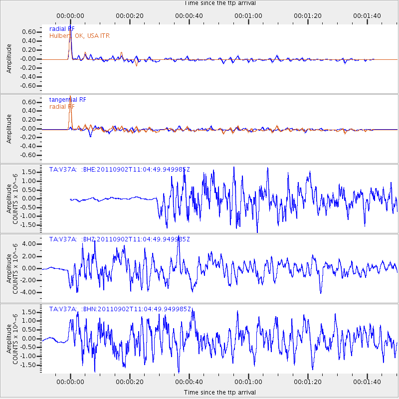
Earthquake location: Fox Islands, Aleutian Islands
Earthquake latitude/longitude: 52.2/-171.7
Earthquake time(UTC): 2011/09/02 (245) 10:55:53 GMT
Earthquake Depth: 32 km
Earthquake Magnitude: 6.5 MB, 6.9 MS, 6.8 MW, 6.8 MW
Earthquake Catalog/Contributor: WHDF/NEIC
Network: TA USArray Transportable Network (new EarthScope stations)
Station: V37A Hulbert, OK, USA
Lat/Lon: 35.88 N/95.14 W
Elevation: 219 m
Distance: 54.8 deg
Az: 75.06 deg
Baz: 312.882 deg
Ray Param: 0.06513555
Estimated Moho Depth: 55.0 km
Estimated Crust Vp/Vs: 1.77
Assumed Crust Vp: 6.498 km/s
Estimated Crust Vs: 3.671 km/s
Estimated Crust Poisson's Ratio: 0.27
Radial Match: 96.478714 %
Radial Bump: 311
Transverse Match: 86.779884 %
Transverse Bump: 400
SOD ConfigId: 414626
Insert Time: 2012-01-18 07:18:31.874 +0000
GWidth: 2.5
Max Bumps: 400
Tol: 0.001

Signal To Noise

ChannelStoNSTALTA
TA:V37A: :BHZ:20110902T11:04:49.949985Z16.4026781.9928182E-61.2149347E-7
TA:V37A: :BHN:20110902T11:04:49.949985Z8.6851597.8884153E-79.0826376E-8
TA:V37A: :BHE:20110902T11:04:49.949985Z12.3680327.480608E-76.0483416E-8
Arrivals
Ps6.9 SECOND
PpPs22 SECOND
PsPs/PpSs29 SECOND