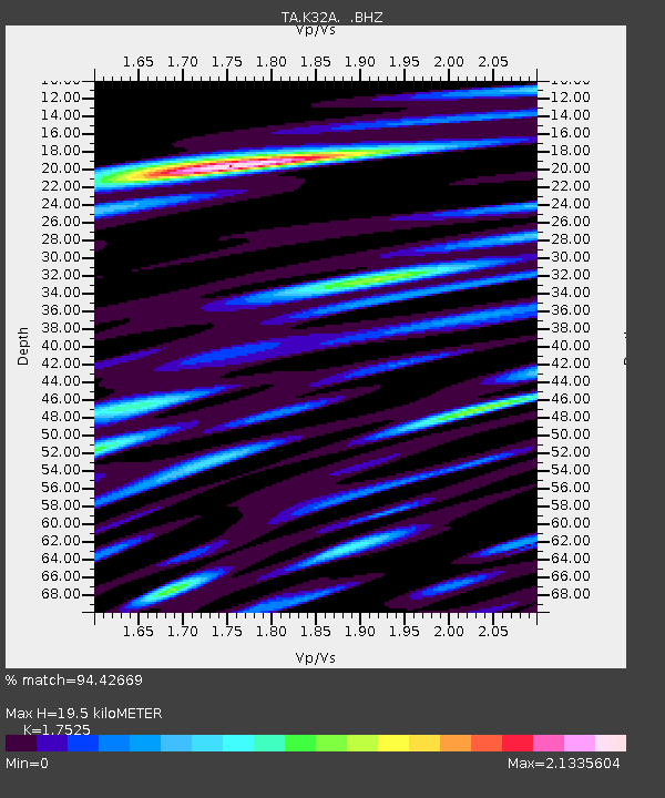
K32A Verdigre, NE, USA - Earthquake Result Viewer
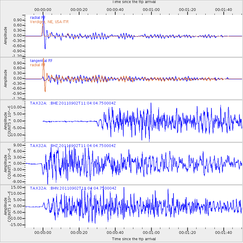
Earthquake location: Fox Islands, Aleutian Islands
Earthquake latitude/longitude: 52.2/-171.7
Earthquake time(UTC): 2011/09/02 (245) 10:55:53 GMT
Earthquake Depth: 32 km
Earthquake Magnitude: 6.5 MB, 6.9 MS, 6.8 MW, 6.8 MW
Earthquake Catalog/Contributor: WHDF/NEIC
Network: TA USArray Transportable Network (new EarthScope stations)
Station: K32A Verdigre, NE, USA
Lat/Lon: 42.66 N/97.97 W
Elevation: 512 m
Distance: 48.8 deg
Az: 70.335 deg
Baz: 308.167 deg
Ray Param: 0.06908161
Estimated Moho Depth: 19.5 km
Estimated Crust Vp/Vs: 1.75
Assumed Crust Vp: 6.498 km/s
Estimated Crust Vs: 3.708 km/s
Estimated Crust Poisson's Ratio: 0.26
Radial Match: 94.42669 %
Radial Bump: 400
Transverse Match: 82.95946 %
Transverse Bump: 400
SOD ConfigId: 414626
Insert Time: 2012-01-18 07:19:42.943 +0000
GWidth: 2.5
Max Bumps: 400
Tol: 0.001

Signal To Noise

ChannelStoNSTALTA
TA:K32A: :BHZ:20110902T11:04:04.750004Z28.8642713.696665E-61.2807062E-7
TA:K32A: :BHN:20110902T11:04:04.750004Z18.046612.582732E-61.4311452E-7
TA:K32A: :BHE:20110902T11:04:04.750004Z17.8974172.554693E-61.4274089E-7
Arrivals
Ps2.4 SECOND
PpPs7.8 SECOND
PsPs/PpSs10 SECOND