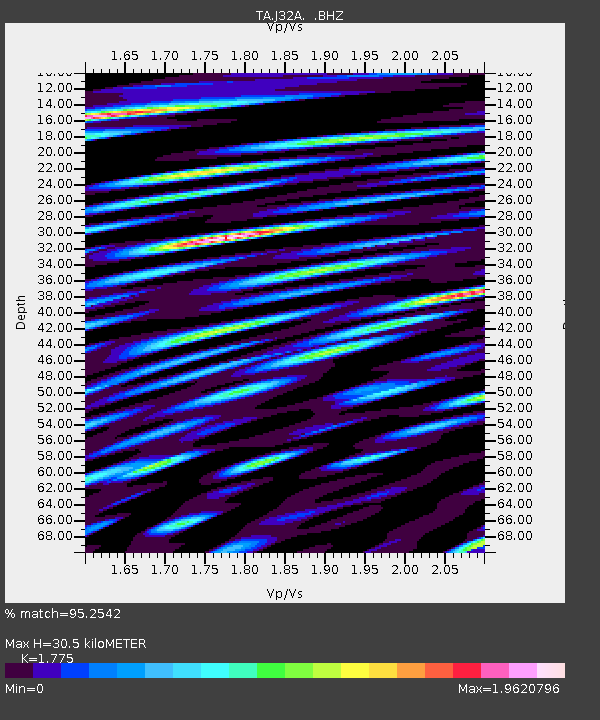
J32A Parkston, SD, USA - Earthquake Result Viewer
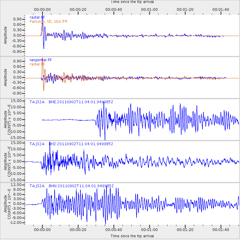
Earthquake location: Fox Islands, Aleutian Islands
Earthquake latitude/longitude: 52.2/-171.7
Earthquake time(UTC): 2011/09/02 (245) 10:55:53 GMT
Earthquake Depth: 32 km
Earthquake Magnitude: 6.5 MB, 6.9 MS, 6.8 MW, 6.8 MW
Earthquake Catalog/Contributor: WHDF/NEIC
Network: TA USArray Transportable Network (new EarthScope stations)
Station: J32A Parkston, SD, USA
Lat/Lon: 43.37 N/97.85 W
Elevation: 399 m
Distance: 48.4 deg
Az: 69.511 deg
Baz: 307.707 deg
Ray Param: 0.06932586
Estimated Moho Depth: 30.5 km
Estimated Crust Vp/Vs: 1.77
Assumed Crust Vp: 6.498 km/s
Estimated Crust Vs: 3.661 km/s
Estimated Crust Poisson's Ratio: 0.27
Radial Match: 95.2542 %
Radial Bump: 400
Transverse Match: 81.26421 %
Transverse Bump: 400
SOD ConfigId: 414626
Insert Time: 2012-01-18 07:19:59.864 +0000
GWidth: 2.5
Max Bumps: 400
Tol: 0.001

Signal To Noise

ChannelStoNSTALTA
TA:J32A: :BHZ:20110902T11:04:01.949985Z33.6696665.119964E-61.520646E-7
TA:J32A: :BHN:20110902T11:04:01.949985Z23.3829333.9871115E-61.7051374E-7
TA:J32A: :BHE:20110902T11:04:01.949985Z25.2040945.748589E-62.2808157E-7
Arrivals
Ps3.9 SECOND
PpPs12 SECOND
PsPs/PpSs16 SECOND