You are here: Home > Network List > TA - USArray Transportable Network (new EarthScope stations) Stations List
> Station I31A Royce, Wessington Springs, SD, USA > Earthquake Result Viewer
I31A Royce, Wessington Springs, SD, USA - Earthquake Result Viewer
| Earthquake location: |
Fox Islands, Aleutian Islands |
| Earthquake latitude/longitude: |
52.2/-171.7 |
| Earthquake time(UTC): |
2011/09/02 (245) 10:55:53 GMT |
| Earthquake Depth: |
32 km |
| Earthquake Magnitude: |
6.5 MB, 6.9 MS, 6.8 MW, 6.8 MW |
| Earthquake Catalog/Contributor: |
WHDF/NEIC |
|
| Network: |
TA USArray Transportable Network (new EarthScope stations) |
| Station: |
I31A Royce, Wessington Springs, SD, USA |
| Lat/Lon: |
44.03 N/98.54 W |
| Elevation: |
469 m |
|
| Distance: |
47.6 deg |
| Az: |
69.215 deg |
| Baz: |
307.035 deg |
| Ray Param: |
0.069824055 |
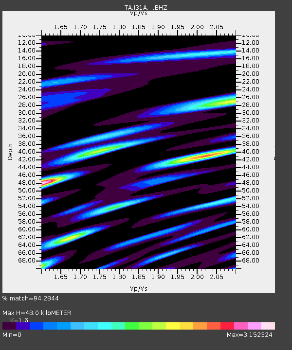
| Estimated Moho Depth: |
48.0 km |
| Estimated Crust Vp/Vs: |
1.60 |
| Assumed Crust Vp: |
6.53 km/s |
| Estimated Crust Vs: |
4.082 km/s |
| Estimated Crust Poisson's Ratio: |
0.18 |
|
| Radial Match: |
94.2844 % |
| Radial Bump: |
400 |
| Transverse Match: |
90.05459 % |
| Transverse Bump: |
400 |
| SOD ConfigId: |
414626 |
| Insert Time: |
2012-01-18 07:20:18.565 +0000 |
| GWidth: |
2.5 |
| Max Bumps: |
400 |
| Tol: |
0.001 |
|

Signal To Noise
| Channel | StoN | STA | LTA |
| TA:I31A: :BHZ:20110902T11:03:55.799991Z | 18.873596 | 4.6175514E-6 | 2.446567E-7 |
| TA:I31A: :BHN:20110902T11:03:55.799991Z | 5.729739 | 2.0030486E-6 | 3.4958808E-7 |
| TA:I31A: :BHE:20110902T11:03:55.799991Z | 6.0148544 | 1.9910203E-6 | 3.310172E-7 |
| Arrivals |
| Ps | 4.7 SECOND |
| PpPs | 18 SECOND |
| PsPs/PpSs | 23 SECOND |


