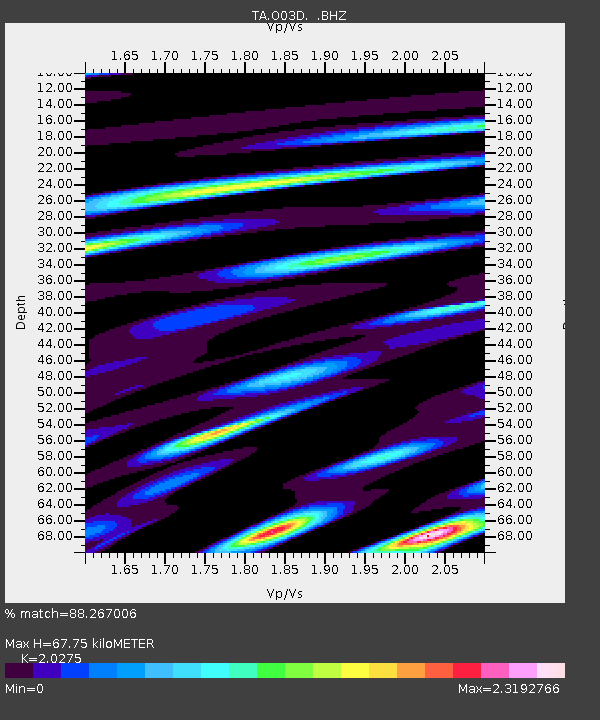
O03D Paynes Creek, CA, USA - Earthquake Result Viewer
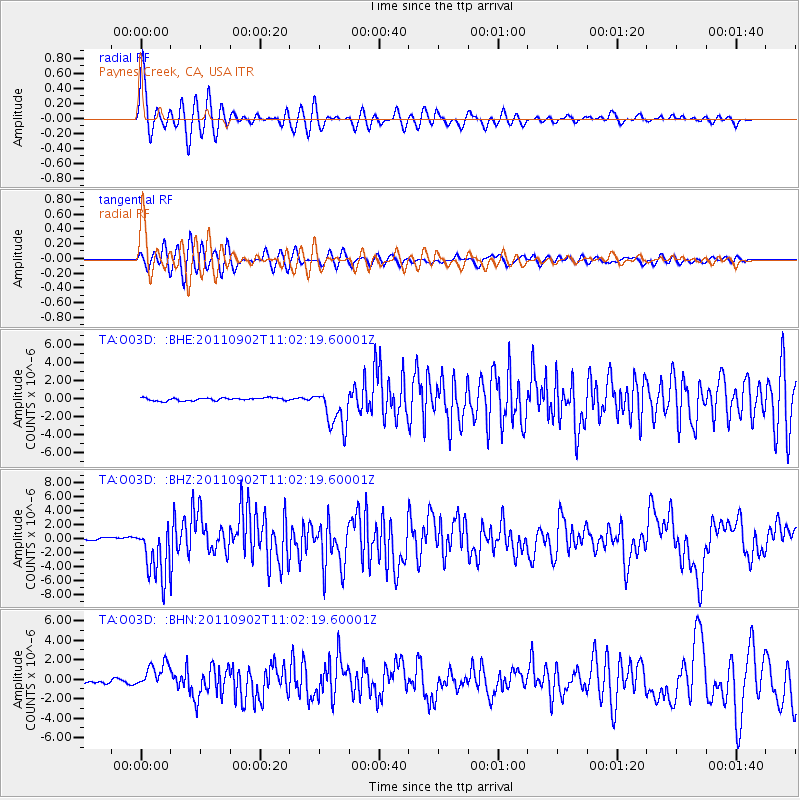
Earthquake location: Fox Islands, Aleutian Islands
Earthquake latitude/longitude: 52.2/-171.7
Earthquake time(UTC): 2011/09/02 (245) 10:55:53 GMT
Earthquake Depth: 32 km
Earthquake Magnitude: 6.5 MB, 6.9 MS, 6.8 MW, 6.8 MW
Earthquake Catalog/Contributor: WHDF/NEIC
Network: TA USArray Transportable Network (new EarthScope stations)
Station: O03D Paynes Creek, CA, USA
Lat/Lon: 40.29 N/121.80 W
Elevation: 968 m
Distance: 35.8 deg
Az: 89.153 deg
Baz: 306.378 deg
Ray Param: 0.0769608
Estimated Moho Depth: 67.75 km
Estimated Crust Vp/Vs: 2.03
Assumed Crust Vp: 6.566 km/s
Estimated Crust Vs: 3.239 km/s
Estimated Crust Poisson's Ratio: 0.34
Radial Match: 88.267006 %
Radial Bump: 400
Transverse Match: 76.74019 %
Transverse Bump: 400
SOD ConfigId: 414626
Insert Time: 2012-01-18 07:22:02.816 +0000
GWidth: 2.5
Max Bumps: 400
Tol: 0.001

Signal To Noise

ChannelStoNSTALTA
TA:O03D: :BHZ:20110902T11:02:19.60001Z17.974093.857937E-62.1463877E-7
TA:O03D: :BHN:20110902T11:02:19.60001Z5.755521.2954292E-62.2507596E-7
TA:O03D: :BHE:20110902T11:02:19.60001Z14.4279492.2529348E-61.5615073E-7
Arrivals
Ps11 SECOND
PpPs29 SECOND
PsPs/PpSs41 SECOND