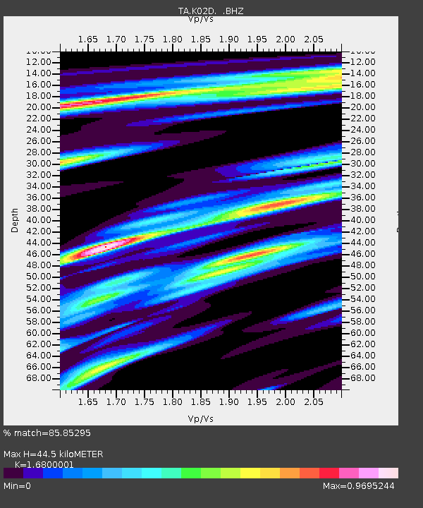
K02D Willamette Meridian, OR, USA - Earthquake Result Viewer
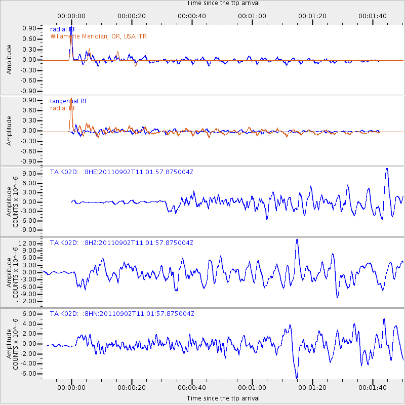
Earthquake location: Fox Islands, Aleutian Islands
Earthquake latitude/longitude: 52.2/-171.7
Earthquake time(UTC): 2011/09/02 (245) 10:55:53 GMT
Earthquake Depth: 32 km
Earthquake Magnitude: 6.5 MB, 6.9 MS, 6.8 MW, 6.8 MW
Earthquake Catalog/Contributor: WHDF/NEIC
Network: TA USArray Transportable Network (new EarthScope stations)
Station: K02D Willamette Meridian, OR, USA
Lat/Lon: 42.70 N/123.67 W
Elevation: 989 m
Distance: 33.3 deg
Az: 87.099 deg
Baz: 303.455 deg
Ray Param: 0.078222856
Estimated Moho Depth: 44.5 km
Estimated Crust Vp/Vs: 1.68
Assumed Crust Vp: 6.522 km/s
Estimated Crust Vs: 3.882 km/s
Estimated Crust Poisson's Ratio: 0.23
Radial Match: 85.85295 %
Radial Bump: 400
Transverse Match: 76.88555 %
Transverse Bump: 400
SOD ConfigId: 414626
Insert Time: 2012-01-18 07:22:11.181 +0000
GWidth: 2.5
Max Bumps: 400
Tol: 0.001

Signal To Noise

ChannelStoNSTALTA
TA:K02D: :BHZ:20110902T11:01:57.875004Z11.0375093.6268577E-63.2859387E-7
TA:K02D: :BHN:20110902T11:01:57.875004Z5.36305671.1754483E-62.1917506E-7
TA:K02D: :BHE:20110902T11:01:57.875004Z6.1616441.859723E-63.0182252E-7
Arrivals
Ps5.1 SECOND
PpPs17 SECOND
PsPs/PpSs22 SECOND