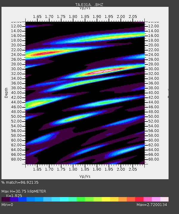
E31A Nome, ND, USA - Earthquake Result Viewer

Earthquake location: Fox Islands, Aleutian Islands
Earthquake latitude/longitude: 52.2/-171.7
Earthquake time(UTC): 2011/09/02 (245) 10:55:53 GMT
Earthquake Depth: 32 km
Earthquake Magnitude: 6.5 MB, 6.9 MS, 6.8 MW, 6.8 MW
Earthquake Catalog/Contributor: WHDF/NEIC
Network: TA USArray Transportable Network (new EarthScope stations)
Station: E31A Nome, ND, USA
Lat/Lon: 46.56 N/97.89 W
Elevation: 427 m
Distance: 46.5 deg
Az: 66.058 deg
Baz: 305.342 deg
Ray Param: 0.07055963
Estimated Moho Depth: 30.75 km
Estimated Crust Vp/Vs: 1.92
Assumed Crust Vp: 6.498 km/s
Estimated Crust Vs: 3.375 km/s
Estimated Crust Poisson's Ratio: 0.32
Radial Match: 96.92135 %
Radial Bump: 356
Transverse Match: 94.318924 %
Transverse Bump: 400
SOD ConfigId: 414626
Insert Time: 2012-01-18 07:23:30.336 +0000
GWidth: 2.5
Max Bumps: 400
Tol: 0.001

Signal To Noise

ChannelStoNSTALTA
TA:E31A: :BHZ:20110902T11:03:47.049991Z40.2150964.0261816E-61.00116175E-7
TA:E31A: :BHN:20110902T11:03:47.049991Z12.5024642.1157534E-61.6922691E-7
TA:E31A: :BHE:20110902T11:03:47.049991Z21.8052562.8140366E-61.2905313E-7
Arrivals
Ps4.6 SECOND
PpPs13 SECOND
PsPs/PpSs18 SECOND