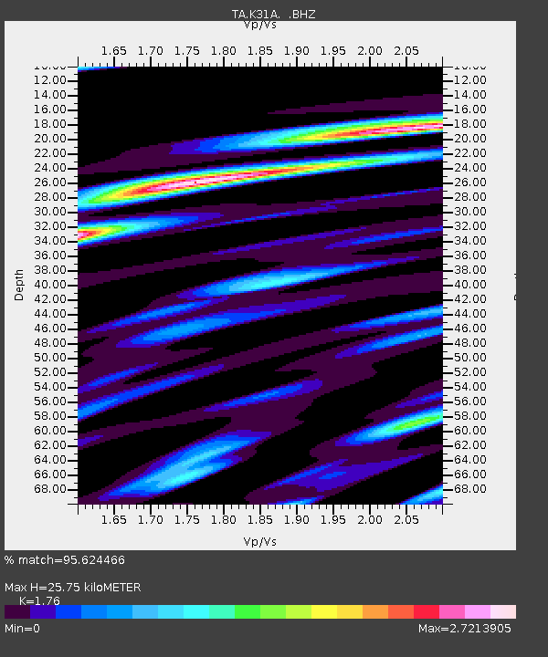
K31A O'Neill, NE, USA - Earthquake Result Viewer
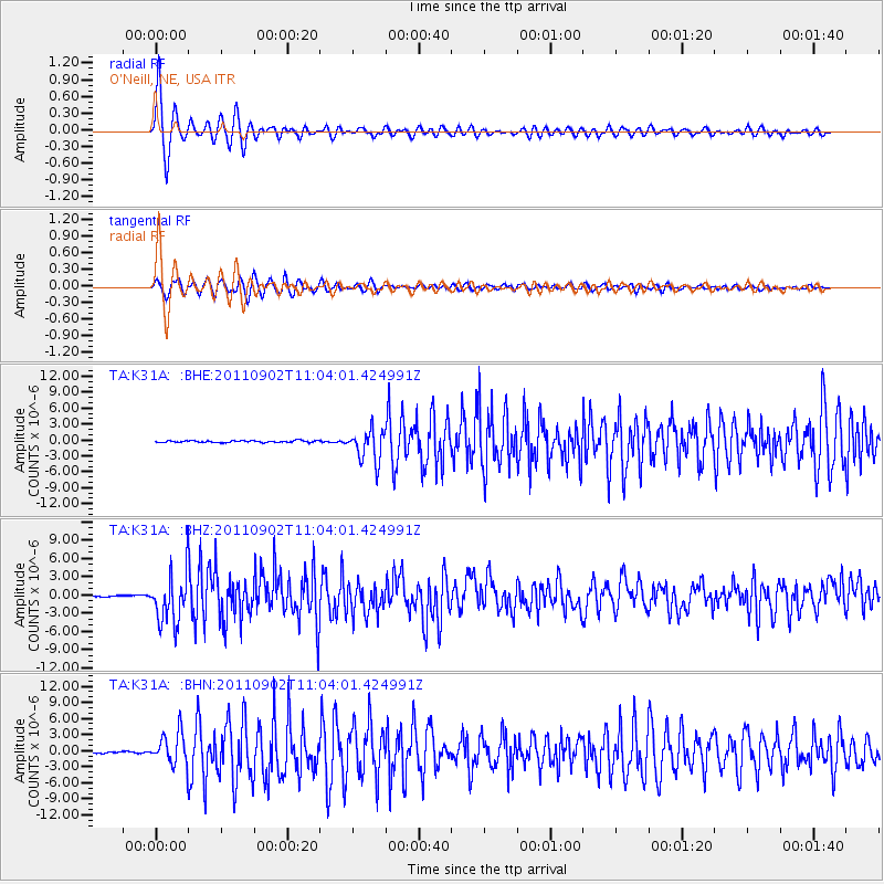
Earthquake location: Fox Islands, Aleutian Islands
Earthquake latitude/longitude: 52.2/-171.7
Earthquake time(UTC): 2011/09/02 (245) 10:55:53 GMT
Earthquake Depth: 32 km
Earthquake Magnitude: 6.5 MB, 6.9 MS, 6.8 MW, 6.8 MW
Earthquake Catalog/Contributor: WHDF/NEIC
Network: TA USArray Transportable Network (new EarthScope stations)
Station: K31A O'Neill, NE, USA
Lat/Lon: 42.62 N/98.75 W
Elevation: 580 m
Distance: 48.3 deg
Az: 70.848 deg
Baz: 307.979 deg
Ray Param: 0.069370106
Estimated Moho Depth: 25.75 km
Estimated Crust Vp/Vs: 1.76
Assumed Crust Vp: 6.53 km/s
Estimated Crust Vs: 3.71 km/s
Estimated Crust Poisson's Ratio: 0.26
Radial Match: 95.624466 %
Radial Bump: 358
Transverse Match: 92.41241 %
Transverse Bump: 400
SOD ConfigId: 414626
Insert Time: 2012-01-18 07:23:56.520 +0000
GWidth: 2.5
Max Bumps: 400
Tol: 0.001

Signal To Noise

ChannelStoNSTALTA
TA:K31A: :BHZ:20110902T11:04:01.424991Z33.573744.0810824E-61.215558E-7
TA:K31A: :BHN:20110902T11:04:01.424991Z24.8492282.963773E-61.1927023E-7
TA:K31A: :BHE:20110902T11:04:01.424991Z16.9812452.9830353E-61.7566646E-7
Arrivals
Ps3.2 SECOND
PpPs10 SECOND
PsPs/PpSs13 SECOND