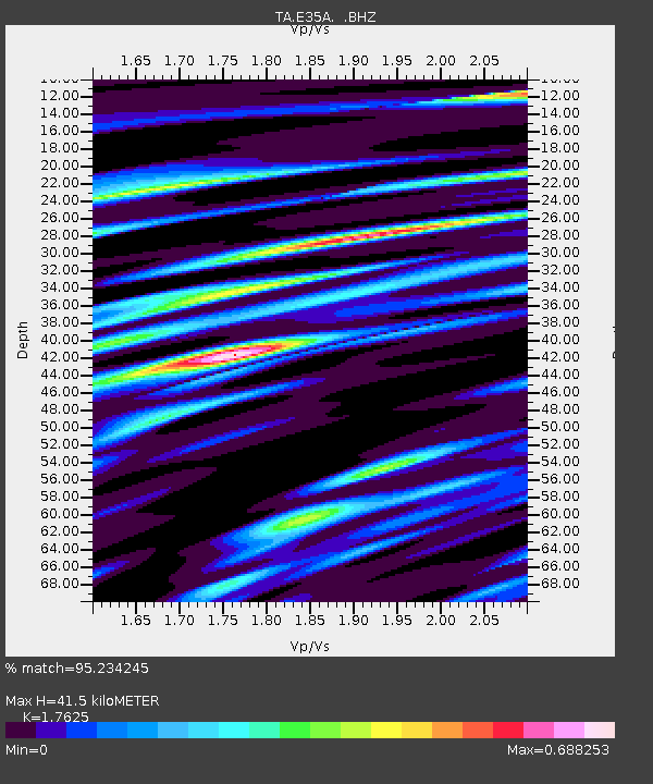
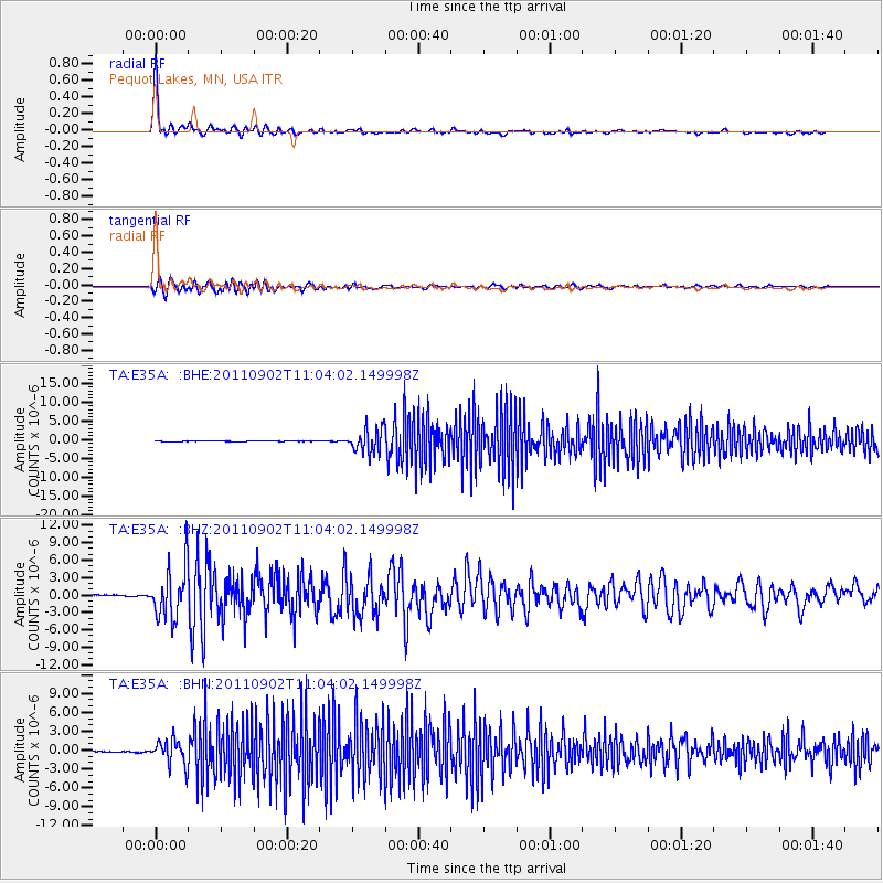
E35A Pequot Lakes, MN, USA - Earthquake Result Viewer

Earthquake location: Fox Islands, Aleutian Islands
Earthquake latitude/longitude: 52.2/-171.7
Earthquake time(UTC): 2011/09/02 (245) 10:55:53 GMT
Earthquake Depth: 32 km
Earthquake Magnitude: 6.5 MB, 6.9 MS, 6.8 MW, 6.8 MW
Earthquake Catalog/Contributor: WHDF/NEIC
Network: TA USArray Transportable Network (new EarthScope stations)
Station: E35A Pequot Lakes, MN, USA
Lat/Lon: 46.56 N/94.40 W
Elevation: 409 m
Distance: 48.4 deg
Az: 64.143 deg
Baz: 306.569 deg
Ray Param: 0.06930813
Estimated Moho Depth: 41.5 km
Estimated Crust Vp/Vs: 1.76
Assumed Crust Vp: 6.419 km/s
Estimated Crust Vs: 3.642 km/s
Estimated Crust Poisson's Ratio: 0.26
Radial Match: 95.234245 %
Radial Bump: 400
Transverse Match: 83.25746 %
Transverse Bump: 400
SOD ConfigId: 414626
Insert Time: 2012-01-18 07:24:33.525 +0000
GWidth: 2.5
Max Bumps: 400
Tol: 0.001

Signal To Noise

ChannelStoNSTALTA
TA:E35A: :BHZ:20110902T11:04:02.149998Z38.412774.4130425E-61.1488478E-7
TA:E35A: :BHN:20110902T11:04:02.149998Z24.9135341.9642882E-67.884422E-8
TA:E35A: :BHE:20110902T11:04:02.149998Z34.1211053.16432E-69.273791E-8
Arrivals
Ps5.2 SECOND
PpPs17 SECOND
PsPs/PpSs22 SECOND