You are here: Home > Network List > TA - USArray Transportable Network (new EarthScope stations) Stations List
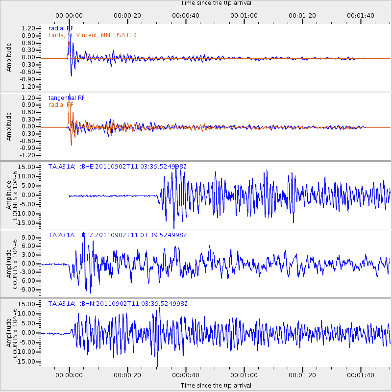
> Station A31A Linda, St. Vincent, MN, USA > Earthquake Result Viewer
A31A Linda, St. Vincent, MN, USA - Earthquake Result Viewer
| Earthquake location: |
Fox Islands, Aleutian Islands |
| Earthquake latitude/longitude: |
52.2/-171.7 |
| Earthquake time(UTC): |
2011/09/02 (245) 10:55:53 GMT |
| Earthquake Depth: |
32 km |
| Earthquake Magnitude: |
6.5 MB, 6.9 MS, 6.8 MW, 6.8 MW |
| Earthquake Catalog/Contributor: |
WHDF/NEIC |
|
| Network: |
TA USArray Transportable Network (new EarthScope stations) |
| Station: |
A31A Linda, St. Vincent, MN, USA |
| Lat/Lon: |
48.93 N/97.19 W |
| Elevation: |
244 m |
|
| Distance: |
45.5 deg |
| Az: |
62.966 deg |
| Baz: |
303.709 deg |
| Ray Param: |
0.071159415 |
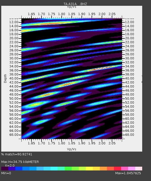
| Estimated Moho Depth: |
34.75 km |
| Estimated Crust Vp/Vs: |
2.00 |
| Assumed Crust Vp: |
6.498 km/s |
| Estimated Crust Vs: |
3.249 km/s |
| Estimated Crust Poisson's Ratio: |
0.33 |
|
| Radial Match: |
90.92741 % |
| Radial Bump: |
400 |
| Transverse Match: |
76.9277 % |
| Transverse Bump: |
400 |
| SOD ConfigId: |
414626 |
| Insert Time: |
2012-01-18 07:24:52.356 +0000 |
| GWidth: |
2.5 |
| Max Bumps: |
400 |
| Tol: |
0.001 |
|
Signal To Noise
| Channel | StoN | STA | LTA |
| TA:A31A: :BHZ:20110902T11:03:39.524998Z | 28.551739 | 3.5075868E-6 | 1.228502E-7 |
| TA:A31A: :BHN:20110902T11:03:39.524998Z | 22.059082 | 3.7521017E-6 | 1.7009329E-7 |
| TA:A31A: :BHE:20110902T11:03:39.524998Z | 27.278706 | 4.711386E-6 | 1.7271296E-7 |
| Arrivals |
| Ps | 5.7 SECOND |
| PpPs | 15 SECOND |
| PsPs/PpSs | 21 SECOND |


