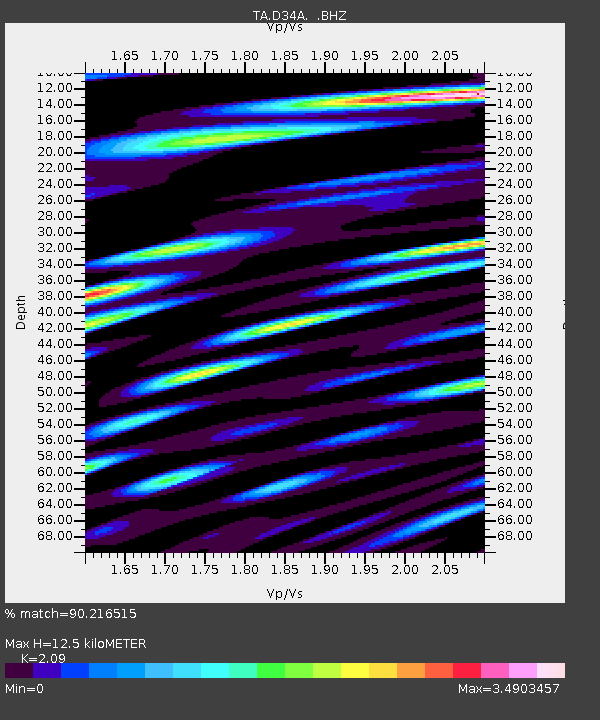
D34A Park Rapids, MN, USA - Earthquake Result Viewer

Earthquake location: Fox Islands, Aleutian Islands
Earthquake latitude/longitude: 52.2/-171.7
Earthquake time(UTC): 2011/09/02 (245) 10:55:53 GMT
Earthquake Depth: 32 km
Earthquake Magnitude: 6.5 MB, 6.9 MS, 6.8 MW, 6.8 MW
Earthquake Catalog/Contributor: WHDF/NEIC
Network: TA USArray Transportable Network (new EarthScope stations)
Station: D34A Park Rapids, MN, USA
Lat/Lon: 47.09 N/95.20 W
Elevation: 476 m
Distance: 47.7 deg
Az: 64.002 deg
Baz: 305.899 deg
Ray Param: 0.06977948
Estimated Moho Depth: 12.5 km
Estimated Crust Vp/Vs: 2.09
Assumed Crust Vp: 6.419 km/s
Estimated Crust Vs: 3.071 km/s
Estimated Crust Poisson's Ratio: 0.35
Radial Match: 90.216515 %
Radial Bump: 400
Transverse Match: 90.60487 %
Transverse Bump: 400
SOD ConfigId: 414626
Insert Time: 2012-01-18 07:25:04.699 +0000
GWidth: 2.5
Max Bumps: 400
Tol: 0.001

Signal To Noise

ChannelStoNSTALTA
TA:D34A: :BHZ:20110902T11:03:56.375004Z25.6890164.5147012E-61.7574442E-7
TA:D34A: :BHN:20110902T11:03:56.375004Z9.1986791.7745184E-61.9291014E-7
TA:D34A: :BHE:20110902T11:03:56.375004Z13.02531052.3615478E-61.8130453E-7
Arrivals
Ps2.2 SECOND
PpPs5.7 SECOND
PsPs/PpSs8.0 SECOND