E34A Wadena, MN, USA - Earthquake Result Viewer
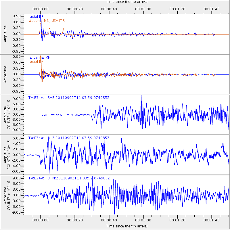
Earthquake location: Fox Islands, Aleutian Islands
Earthquake latitude/longitude: 52.2/-171.7
Earthquake time(UTC): 2011/09/02 (245) 10:55:53 GMT
Earthquake Depth: 32 km
Earthquake Magnitude: 6.5 MB, 6.9 MS, 6.8 MW, 6.8 MW
Earthquake Catalog/Contributor: WHDF/NEIC
Network: TA USArray Transportable Network (new EarthScope stations)
Station: E34A Wadena, MN, USA
Lat/Lon: 46.51 N/95.17 W
Elevation: 430 m
Distance: 48.0 deg
Az: 64.611 deg
Baz: 306.327 deg
Ray Param: 0.06956109
Estimated Moho Depth: 16.75 km
Estimated Crust Vp/Vs: 1.60
Assumed Crust Vp: 6.419 km/s
Estimated Crust Vs: 4.006 km/s
Estimated Crust Poisson's Ratio: 0.18
Radial Match: 83.29688 %
Radial Bump: 400
Transverse Match: 66.15752 %
Transverse Bump: 400
SOD ConfigId: 414626
Insert Time: 2012-01-18 07:25:24.745 +0000
GWidth: 2.5
Max Bumps: 400
Tol: 0.001

Signal To Noise

ChannelStoNSTALTA
TA:E34A: :BHZ:20110902T11:03:59.074985Z25.2557532.881557E-61.1409508E-7
TA:E34A: :BHN:20110902T11:03:59.074985Z12.673081.3404446E-61.0577102E-7
TA:E34A: :BHE:20110902T11:03:59.074985Z17.9004922.285672E-61.2768767E-7
Arrivals
Ps1.7 SECOND
PpPs6.4 SECOND
PsPs/PpSs8.0 SECOND