You are here: Home > Network List > TA - USArray Transportable Network (new EarthScope stations) Stations List
> Station I36A Fitzsimmons Farm, Good Thunder, MN, USA > Earthquake Result Viewer
I36A Fitzsimmons Farm, Good Thunder, MN, USA - Earthquake Result Viewer

| Earthquake location: |
Fox Islands, Aleutian Islands |
| Earthquake latitude/longitude: |
52.2/-171.7 |
| Earthquake time(UTC): |
2011/09/02 (245) 10:55:53 GMT |
| Earthquake Depth: |
32 km |
| Earthquake Magnitude: |
6.5 MB, 6.9 MS, 6.8 MW, 6.8 MW |
| Earthquake Catalog/Contributor: |
WHDF/NEIC |
|
| Network: |
TA USArray Transportable Network (new EarthScope stations) |
| Station: |
I36A Fitzsimmons Farm, Good Thunder, MN, USA |
| Lat/Lon: |
44.02 N/94.01 W |
| Elevation: |
307 m |
|
| Distance: |
50.2 deg |
| Az: |
66.578 deg |
| Baz: |
308.433 deg |
| Ray Param: |
0.06816266 |
| Estimated Moho Depth: |
29.5 km |
| Estimated Crust Vp/Vs: |
2.09 |
| Assumed Crust Vp: |
6.571 km/s |
| Estimated Crust Vs: |
3.144 km/s |
| Estimated Crust Poisson's Ratio: |
0.35 |
|
| Radial Match: |
81.085434 % |
| Radial Bump: |
400 |
| Transverse Match: |
74.27188 % |
| Transverse Bump: |
400 |
| SOD ConfigId: |
414626 |
| Insert Time: |
2012-01-18 07:27:41.289 +0000 |
| GWidth: |
2.5 |
| Max Bumps: |
400 |
| Tol: |
0.001 |
|
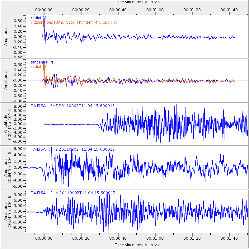
Signal To Noise
| Channel | StoN | STA | LTA |
| TA:I36A: :BHZ:20110902T11:04:15.60001Z | 17.435253 | 2.142161E-6 | 1.2286378E-7 |
| TA:I36A: :BHN:20110902T11:04:15.60001Z | 16.623981 | 2.0065213E-6 | 1.207004E-7 |
| TA:I36A: :BHE:20110902T11:04:15.60001Z | 16.44245 | 1.7259722E-6 | 1.049705E-7 |
| Arrivals |
| Ps | 5.2 SECOND |
| PpPs | 13 SECOND |
| PsPs/PpSs | 18 SECOND |


